RECENT DISCOVERIES AT OSTIA
By THOMAS ASHBY, D.Litt.
Journal of Roman Studies 2 (1912), 153-194.
Click here to load Ashby's plan in a separate window
153
I. SKETCH OF THE HISTORY OF OSTIA.
The west coast of Italy between the gulf of Spezia, once the harbour of Luna, and the bay of Gaeta does not at the present day offer a single safe anchorage for ships of any size, and even in early days, when ships were smaller, its harbours and landing places must have seemed very deficient. The cities of south-western Etruria had indeed developed a flourishing seaborne trade by the seventh century B.C. when they were importing freely from Greece, but the ports of their two leading towns, Tarquinii and Caere, which seem to have been at Graviscae and Pyrgi, were merely roadsteads. Strabo, in his summary of the ports along this littoral, mentions none between Monte Argentario and Ostia, and none again between Ostia and the bay of Gaeta. Such ports as there ever were, are of later origin. Centumcellae, the modern Civitavecchia, is a foundation of Trajan; the harbour of Antium, such as it was, was due to Nero, and the port of Terracina is the work of Pius. Even Ostia itself was in Strabo's time deemed a bad harbour and the Tiber estuary hard to enter. Good or bad, however, it was the one approach to a natural harbour on all this coast.
The early history of Ostia is obscure. Legends ascribe it to the mythical king Ancus Martius, and place it first in the list of Roman coloniae. No doubt its real origin is connected with the salt marshes which have lain round the Tiber mouth from prehistoric days till 40 years ago and with the oldest of Roman roads, the Saltway (Via Salaria), which ran inland from them. Probably it was a successor of an older town, Ficana, which stood a little further inland, at the eleventh milestone from Rome on the Via Ostiensis according to Festus, and according to modern writers on a little hill which rises sixty feet above the river and is crowned with the modern farmhouse of Dragoncello. A cult of Mars Ficanus, which can be traced at Ostia,(1) seems to imply that Ostia was regarded as the heir to Ficana, when that, according to the legend, had been destroyed by Ancus Martius. In classical writers we have but few actual references to early Ostia. An allusion by Dionysius of Halicarnassus, in his account of Spurius Maelius, stands almost
(1) C.I.L. xiv, 309.
154
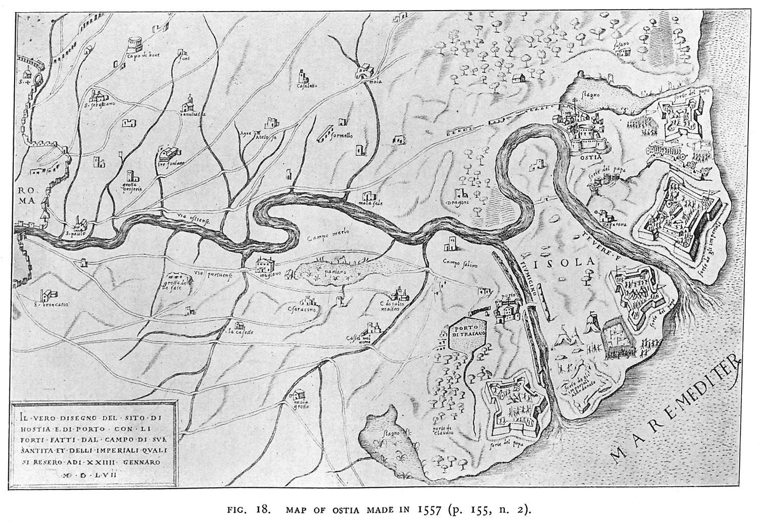
Fig. 18. MAP OF OSTIA MADE IN 1557 (p. 155, n. 2).
155
alone, and recent discoveries tend to show that there are no traces on the site of Roman Ostia and its necropolis of dwellings or tombs earlier than the third century B.C.(1) Possibly the earliest village lay on the other side of the marshes, nearer to Rome and on the right hand, or north of the line of the Via Ostiensis. This is a mile or so from the present stream, but not far from its course previous to the great flood of 1557, which altered the estuary of the Tiber in many important points.(2) That, however, is a conjecture as to which recent discoveries have told us little.
The earliest surviving remains of Ostia are to be found in the lowest strata of the Roman town and may be dated to some part of the third century B.C. They are not many. There are tombs in the sand, on the site of the later cemetery (see plan, fig. 29, no. 4), somewhat damaged when that was made, but showing ollae for ashes, wooden coffins, well carved bone fragments and a Boeotian coin of about 200 B.C. There are also traces of oval huts made of brushwood, just within the later city wall (plan, no. 9). That is about all.(3) It seems probable, as Prof. Vaglieri and M. Carcopino have conjectured independently, that the foundation of Ostia on its present site may be connected with the institution of the four quaestores classici in 267 B.C. and the assignment of one of them to Ostia. In the First Punic War, however (264-241 B.C.), Ostia does not appear as a port. It is not till the Second Punic War (217 B.C. foll.) that it is mentioned as a naval base and as the harbour of Rome.(4) An interesting relic of a somewhat later period of its existence has occurred in a hoard of about 600 republican coins found in 1909. Of this hoard 176 coins were examined by Signor Gnecchi and were determined to date from 244-159 B.C. The hoard may, therefore, have been deposited somewhere about 155 B.C.(5)
Not a few buildings can be assigned to the republican period of the last two centuries B.C. Here the recent researches of Prof. Vaglieri have yielded most valuable fruit. He has found remains of the city walls on the side towards Rome, built of opus incertum about 6 feet thick (plan, no. 6). He has also identified the gate by which the Via Ostiensis entered the town. This gate was 20 feet wide and 40 feet deep, with doors at each end of the long passage. It was retained in imperial times, refaced, decorated with marble,
(1) Vaglieri, Bull. Com. xxxix (1911), 225, foll.
(2) See the map of the Campagna in 1547, preserved in six sheets in the Vatican library. This map will shortly be published with a commentary by myself at the request of the Prefect of the library, Father Ehrle, S.J. A map made early in 1557 and derived from that of 1547, but altered in details, is here reproduced (fig. 18). It shows the forts erected by Alva's troops for their attack on the castle of Ostia, which he took in November, 1556, but lost again early in 1557. On the question of the Tiber mouth in ancient times see further in the appendix to this paper.
(3) Vaglieri, Notizie Scavi, 1912, p. 95.
(4) Livy, xxii, 11, 37, 57, etc.
(5) Gnecchi, Rivista Italiana di Numismatica, 1909, pp. 11, foll. The exact site of the find seems uncertain; compare Vaglieri, Bull. Com. cit. p. 244.
156
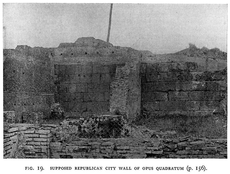
and the passage was repaved with selce instead of gravel. The walls towards the sea have not yet been traced, but a fragment of wall of opus quadratum has been suggested as part of them (fig. 19). Some of the tombs in the cemetery outside the gate seem also to belong to the republican period.
Inside the gate, on the right as one enters, are the foundations (plan, no. 13) of a building 100 feet long, apparently a long rectangular structure with a double line of pillars down the middle. Under the empire, walls were added to the pillars and there resulted a corridor with rooms on each side; curiously enough, there was no opening
on to the street, and the building may have been used as a warehouse giving on to the neighbouring river-bank. In republican times, this was part of a larger area of state-land of which the boundary was marked by inscribed terminals. Three of these are known (see plan, nos. 7 and 14),(1) all bearing the same inscription, C. CANINIUS C. F. PR(AETOR) URBANUS DE SEN(ATUS) SENT(ENTIA) POPLIC(OM) IOUDIC(AVIT), and are not later than Sulla, being thus the oldest inscriptions yet found in Ostia.
(1) The third is nearly opposite the opening of the Via dei Vigili.
157
Further from the gate, along the main street which the Italian archaeologists call the Decumanus (plan, no. 12), are the remains of a portico with tufa columns (plan, no. 26), and further on, opposite the theatre, is the base, it may be, of a temple or shrine 20 feet square (plan, no. 27).
Finally, I have to mention a podium, 112 feet long by 38 feet wide, built of opus reticulatum, which supported four small temples, close to the later Mithraeum (plan, no. 34). Part of an enclosure-wall of the same construction, belonging perhaps to the sacred precincts round these temples, has also been traced (plan, no. 32). Excavations within the podium have brought to light fine decorative terra-cottas of the latest republican period.(1)
These discoveries seem to show that the main outlines of the later plan of Ostia were already laid down in its republican period. The main street, the so-called Decumanus, was a prolongation of the road from Rome to Ostia, and it is along this street that all the buildings mentioned above have been found. In the later town, however, the orientation dictated by the road from Rome and its continuation in this street, which was laid out so as to leave space for warehouses between it and the river bank, conflicts with another orientation depending, it seems, on the line of the sea coast (plan, nos. 49-51). In the part of Ostia which has so far been uncovered, the former is the dominant orientation, but the line of the Via dei Sepolcri shows an attempt to compromise between the two.
Caesar seems to have done nothing at Ostia. He had, we are told, intended to build a harbour and to dredge the foreshore, but death cut short these and many other of his plans. We can hardly tell, indeed, which of many schemes attributed to him he really had in mind and which have been ascribed to him by the admiration of later ages.
I pass on to the earlier imperial period. Ostia was then, as Strabo tells us, still a city "without a harbour, owing to the silting up brought about by the Tiber. . . . The ships anchor in the roadstead, not without danger, but the love of gain prevails, for the large number of lighters which receive the cargoes and reload them renders the time short before they can enter the river, and having lightened part of their cargo, they sail in and go up to Rome" (v, p. 231).
It has not yet been possible to form a general conception of the city at the beginning of the first century after Christ. A certain number of buildings of the Augustan period have already emerged. They include a few tombs, with which we may deal later though it will be well to mention at once the inscription of a soldier of the sixth praetorian cohort, to whom the city of Ostia gave a public
(1) So Vaglieri: Delbrück, however, thinks the podium Augustan (Archäol. Anzeiger, 1912, p. 300).
158
funeral and a site for the tomb because he perished in the attempt to extinguish a fire:
. . . MILITI COHOR(TIS) VI PR(AETORIAE) OSTIENSES LOCUM SEPULT(URAE) DEDERUNT PUBLICOQ(UE) FUNERE EFFERUN(DUM) DECRERUNT, QUOD IN INCENDIO RESTINGUENDO INTERIT.
Vaglieri (1) attributes this, no doubt correctly, to the Augustan period, owing to the low level at which it stands. If so, it is perhaps a testimony to the presence of this cohort in Ostia before Tiberius concentrated the force in Rome. The theatre was also constructed under Augustus, and remains of the original building in opus reticulatum can be recognised, though confused with the work of three reconstructions.
There are remains, too, of buildings of the early imperial period, apparently thermae, partly under the site later occupied by the barracks of the vigiles, and partly under the street in front of them (plan, no. 18). Traces of earlier constructions of brick have also come to light under the thermae, belonging to several different dates, and the great reservoir under the palaestra probably belongs to the first century of the empire also. Its outer walls are of opus reticulatum, with brick quoins: it has external buttresses on the north side, sloped off at the top, and obviously intended to be seen; while the footing of its walls lies at the level which is to be associated with this period.
Claudius, here as elsewhere, turned his attention to the realisation of the projects of Caesar. He constructed a large harbour on the right bank, 2 1/2 miles to the north of the mouth of the river, at the point where the Tiber approaches nearest to the coast, and connected the port with the river by a canal, thus forming an island and liberating the city of Rome, as he claimed, from the danger of inundation. He seems to have completed but not to have dedicated it, for coins issued by the senate under Nero represent it as a new work under the name of Portus Augusti, which apparently thenceforth came into use. The harbour itself was probably difficult to enter, for we learn that 200 ships foundered off Ostia in a storm in A.D. 62. From the period of Domitian dates the reconstruction of Ostia town, on the same plan but at a higher level, in the form in which it lies before us; this was continued by his successors. That Domitian began the work is inferred by Prof. Vaglieri from the presence of brickstamps of his reign in many of the important drains,(2) from the existence, on the great waterpipe which carried the main supply, of an inscription recording his tenth consulate, and from other indications. But Hadrian and the Antonines were responsible for the greater part of the work, as we
(1) Notizie Scavi, 1912, p.23.
(2) e.g. that of the "Via dei Vigili" (infra, p. 174).
159
shall see later. Trajan's main activity was displayed in the construction of an inner basin adjacent to the harbour of Claudius, and connected with it and with his canal, which was also prolonged so as to give direct access to the sea. The work was completed between A.D. 103 and 106, and he also constructed the port of Centumcellae, the modern Civitavecchia, some 37 miles to the north-west. Other reconstructions took place under Septimius Severus and Caracalla: and their successors did not neglect the town; but the brickwork of Ostia requires the same minute study which has been given to that of Rome (1) before we can consider ourselves in a position to date it accurately in all cases.
During all these reigns, the new harbour, Portus, on the other side of the island, was a part of Ostia, both for administrative and for religious purposes. Even the trading guilds seem to have been, as a rule, common to the two harbours, though Portus had some of its own. At last, the age of the advent of Christianity saw a change. In 313 a bishop of Ostia was present at the council which Constantine summoned in Rome, while in the next year's council at Arles, two presbyters came from Ostia, and a bishop de loco qui est in portu Romae. Thenceforth, the latter is called Portus urbis Romae or Portus Romanus.
The walls by which it is defended can hardly be much earlier or much later than the Constantinian period, and the name Via Portuensis is first applied at this date to the road which led to it from Rome. There are, on the other hand, no traces of buildings erected by Constantine in Ostia,(2) and it seems clear that, from his time onwards, Portus became more important than Ostia. Rutilius, leaving Rome about A.D. 414, describes his departure thus: "tum demum ad naves gradior qua fronte bicorni | dividuus Tiberis dexteriora secat. | Laevus in accessis fluvius vitatur arenis | hospitis Aeneae gloria sola manet!" Cassiodorus, it is true, speaks of the two cities (3) as "duo Tiberini alvei ornatissimae civitates, tamquam duo lumina"; but Procopius,(4) not many years later, in A.D. 537, describes Ostia as far from the bank of the river, and undefended by walls, and the Via Ostiensis as entirely neglected; whereas ships came up to Portus and discharged their cargo into barges, which were then towed up to Rome by oxen. It is he who first speaks of the island as the "holy island," and it still retains the name of Isola Sacra.(5)
(1) Miss E.B. Van Deman, The date of Roman Concrete Monuments in A.J.A. 1912, 230, 387.
(2) Whether the basilica of SS. Peter and Paul was situated at Ostia or Portus is disputed: Kehr, Italia Pontificia, ii, 14; Paschetto, Ostia, 86.
(3) Variar. vii, 9.
(4) B.G. i, 26.
(5) A fragment of an inscription which ran as follows: "Vandalica rabies hanc ussit martyris aulam quam Petrus Antistes cultu meliore novatam," is referred by Cantarelli, Bull. Com. (1896), 67, to a church on the island; it probably alludes to the raid of the Vandals in A.D. 455.
160
The remains of Ostia bear similar testimony. A Christian chapel was built behind the theatre, but otherwise there is little evidence of late building activity. The aqueduct was cut, and some parts of the theatre turned into cisterns. A pile of broken tile fragments was found in the courtyard of the barracks of the vigiles, ready to be removed to make a pavement elsewhere, while late burials were found both here and in the thermae. A century and a half later on, about A.D. 690 or 700, we find that the basilica of S. Aurea was "disiecta vel disrupta," and had to be restored by pope Sergius I. The damage may have been due to neglect, or to some predecessors of the Saracens, whose incursions impelled pope Gregory IV (827-844) in his care for the city of Ostia to construct "civitatem aliam a solo valde, fortissimam, muris quoque altioribus," to which the name of Gregoriopolis was given. There has been much discussion as to whether Gregoriopolis is to be placed, as seems most likely, near the basilica of S. Aurea, where the mediaeval village sprang up, and where the castle still stands, or whether it is to be sought among the ruins of the ancient city, where some have pointed to doorways blocked up in late days as evidences of Gregory's activity. It is more likely, however, that this particular procedure should be attributed to the inhabitants of Ostia itself who, during the reign of the next pope, when the invaders returned "(urbem) obstruxerant et effugerunt." This seems to have been done by demolishing tombs and other buildings, and filling up a great part of the city, so that it should not serve as a shelter for pirates.(1) Nicholas I (858-867) restored Gregoriopolis, which was already "lying in ruins," and no doubt destined to further piratical incursions: but we cannot now attempt to trace its history through the middle ages.(2)
Ancient Ostia, in the meanwhile, had become a quarry, and was searched in the eleventh century for marble for the cathedral of Pisa (3) and in the fourteenth century for that of Orvieto. Near the end of the fifteenth century Giuliano della Rovere, nephew of the reigning pope Sixtus IV, and afterwards pope Julius II, constructed the splendid castle of Ostia on the banks of the river, close to the mediaeval village, which apparently owes its walls to the year 1471. The castle is from the designs of Baccio Pontelli. The casemates are especially good, and it is one of the finest of early renaissance defensive works. We have already seen how the flood of 1557, by removing the bed of the river far from it, left it without a raison d'être.
(1) Carcopino, in Mélanges, xxx (1910), 437, n.
(2) See Tomassetti, Campagna Romana nel Medio Evo, Via Ostiense, 106, f.
(3) C.I.L. xiv, no. 9, a cippus dedicated to the genius coloniae Ostiensis, still standing on the outside of the cathedral; ibid. no. 292, a sarcophagus now in the Camposanto: cf. also ibid. no. 105. It may well have been the Pisans who carried ibid. no. 346 to a church in northern Sardinia.
161
II. HISTORY OF EXCAVATIONS AT OSTIA TO 1907.
The history of the antiquities of Ostia begins with the renaissance,(1) when the ruins were mainly searched for building materials, though objects of art were also found. The first real excavations, however, were, not conducted until the last quarter of the eighteenth century, for the place was malarious and none too safe; and even in them, unfortunately, the main object was the discovery of works of art. The first investigations of which we have any record are those conducted by the Scottish artist, Gavin Hamilton, in 1774-1775,(2) at the so-called Porta Marina (plan, no. 51), in the remains of the thermae maritimae, as was clear from their plan. Inscriptions were also found recording their completion by Antoninus Pius (not Hadrian) in A.D. 139, and their restoration successively by Constantius and Constans in 337-350, and by Gratian and Valentinian in 375-378. Among the statues discovered were the Antinous now at Marbury Hall,(3) the Hygeia of Cassel,(4) and the torso restored as Diomede.(5) "Little more of consequence was found at Porta Marina," says Hamilton, "as I found that others had been there before me, so we proceeded to another ruin on the seashore, which from some fragments found above ground gave great hopes. A bath was first discovered with the pavement of verd antique and a fine torso of a young man, of which most of the other parts were found much broke excepting the head. . . . The present pope Pius VI has ordered it to be restored for the museum."(6) Here were also found the two Venuses and the Thalia, which passed into Townley's hands and are now in the British Museum,(7) together with four groups of the labours of Hercules,(8) and a tripod of Apollo (9) which was ceded by the treaty of Tolentino, and is now in the Louvre.(10)
Others soon began to try their fortune. In 1783 a chance discovery of a villa with fine sculptures was made along the road three miles away, and in the same year the Portuguese minister, Di Norogna, made excavations near the oil stores (plan, no. 45) and found some rooms with fine coloured mosaics and numerous large earthenware
(1) Paschetto, 104, ff.
(2) The date of Hamilton's first discoveries is given by his own letters (cf. A. H. Smith in J.H.S. xxi, 1901, 314). For the inscriptions, cf. Dessau in Eph. Epigr. ix, p. 334. I think it is almost certain that the "very elegant inscription of the time of Trajan" is really C.I.L. xiv, 98: Hamilton was no scholar. In that case these were the baths which the second Gamala rebuilt after a fire (C.I.L. xiv, 376): see below, p. 172, and p. 181, n. 2.
(3) Michaelis, Anc. Marbles, no. 20: cf. Hamilton's own letter of May 1st, 1774, published by Smith, Lansdowne Marbles, p. 71; he says that it was found on the mosaic pavement near its pedestal, but at first without its head. Paschetto has not consulted Hamilton's correspondence.
(4) Reinach, Rép. ii, 298, I.
(5) Lansdowne House, no. 87.
(6) I cannot identify it.
(7) B.M. nos. 1574, 1577, 1685.
(8) Vatican, Sala degli Animali, 139, 141, 208, 213.
(9) Visconti, Museo Pio Clem. vii, 41.
(10) Froehner, Notice, 90; Cat. Somm. no. 1617.
162
jars (dolia), several of which now stand in front of Castel Fusano, a shooting-box in the picturesque pinewoods to the south-east. The engraver Volpato also did some digging, but with indifferent success. In 1794 Robert Fagan, an English artist, who was also British consul, began his excavations at Ostia near the site selected by Hamilton, but more towards Torre Bovacciana (plan, no. 49), keeping, that is, along the coastline of the imperial period. The work continued until 1800, and led to the discovery of numerous works of art, the majority of which went to the pontifical collections, though a few were sent to England.(1) The former include the Fortune in the Vatican.(2) Fagan seems also to have returned to the neighbourhood of the site where the Portuguese ambassador had dug, where he found a circular structure with a pavement in mosaic representing marine scenes, probably therefore a bath. Here also he discovered a statue of Mars, bought by Lord Bristol, and now lost, and a Ganymede now in the Vatican(3): he also came upon a Mithraeum, the sculptures from which are also in the Vatican,(4) the first of many that were to be discovered in the future.
Soon after, Pius VII decreed that excavations by private persons should no longer be permitted, and decided that official work should be begun in the winter of 1801, under the direction of Giuseppe Petrini, galley-slaves from Civitavecchia being employed as workmen. Excavation was commenced near the shore, and a large building decorated with frescoes and mosaic pavements was found, and later on a villa. In the winter of the next year excavations were resumed on a larger scale. Unluckily however, no proper description of the work remains; with very few exceptions, no detailed plans were taken or published, and though a list of the many objects found has been preserved in manuscript, and has now been published by Paschetto,(5) the localities are not given. It would seem that, besides the great temple itself, the most prominent building in the ruins (plan, no. 40 and fig. 20), the sites cleared were to the north, west and south of it.
The next excavations were made by one Cartoni in 1824-1825 to the southwest of the modern village, apparently in a necropolis along the line of a branch road leading from the Via Ostiensis to the Via Severiana without entering the town. Numerous sepulchral inscriptions and some sarcophagi were found.(6) He also made trial
(1) The Athena and Hygeia at Deepdene (Michaelis, 39, 7).
(2) Braccio Nuovo, no. 86.
(3) ibid. no. 38 B.
(4) Museo Chiaramonti, nos. 567-569, Cort. Belv. 1028.
(5) p. 508, ff. In most cases Paschetto has made no attempt to identify the objects mentioned in this list, with the exception of the inscriptions. It is not an easy task, but should not have been omitted: cf. Nogara, Guide to the Vatican Museum of Sculpture, index s.v. Ostia.
(6) Paschetto, tav. ii, 14. Paschetto has omitted the Ariadne and Endymion sarcophagi in Munich (Glyptothek, 189, 223; cf. Robert, S.R. iii, P. 79, no. 64); nor has he examined Robert's work, which would have told him the fate of the other Endymion sarcophagus (bearing the inscription C.I.L. xiv, no. 565). It was taken to Warwick Castle and destroyed by fire in 1871.
163
164
diggings within the area of the city, and found and destroyed some remains of baths to the west of the theatre. In 1831-1835 cardinal Pacca employed Pietro Campana to excavate for him in the suburbs of Ostia, and tombs with numerous inscriptions (several of which were Christian), and some sarcophagi came to light. Many of the objects found have been dispersed.(1) Some trials were also made within the area of the city, but we have no proper information about them, and Paschetto is right in saying that it would have been better if the excavations with which we have dealt hitherto had never been undertaken.
The first even relatively scientific investigations were begun in 1855 by Pietro Ercole Visconti, assisted by his nephew, Carlo Ludovico Visconti, immediately outside what was then believed to be the Porta Romana, and numerous tombs were discovered. In the autumn of 1857,the so-called "docks" (plan, no. 46) and the "imperial palace," near Torre Bovacciana (plan, no. 48) were excavated, and in 1864-1870 a group of tombs (plan, no. 53) along the coast road of the Via Severiana leading south-eastwards. The temple of Cybele with the buildings attached to it (plan, no. 52), and some remains of thermae near the Porta Marina (plan, no. 50), which are perhaps a part of the thermae maritimae, were also brought to light, while supplementary excavations were carried on at various other points. Fairly good reports were published, especially in the Annali dell' Istituto,(2) and the objects found were placed in two special rooms in the Lateran, though the idea of a local museum had already been entertained.
The Italian government continued the work in 1871-1878, but little was done, except for the complete clearing of the commercial quarter to the north of the great temple (plan, nos. 39, 41-44), which, as M. Jerome Carcopino (3) points out, had been tried by various excavators, but finished by none. He gives a useful plan and description of it. In 1880-1881 work was begun again under Professor Lanciani,(4) who had assisted in the previous excavations from 1867 onwards, and the theatre was cleared (plan, no. 28); in 1885-1889 the open space behind it, with the temple and some of the scholae, was laid bare, and also the house, the Mithraeum, the four temples, and other buildings to the west of it, part of the thermae to the east, and part of the barracks of the vigiles to the north (plan, nos. 29-34, 17, 19).(5)
From 1889 almost nothing was done, with the exception of the clearing of the "Via della Fontana" (plan, no. 22), until the com-
(1) To the list given by Paschetto may be added the sarcophagus with the myth of Endymion now in Ny-Carlsberg (no. 1299: Robert, S.R. iii, p. 68, no. 49).
(2) The full bibliography is given by Paschetto, p. 539, ff.
(3) Mélanges, xxx (1910), 401.
(4) See his reports in Not. Scavi, passim.
(5) The plan and restoration of André in Mélanges, xi (1891), 492, ff. give an excellent idea of what had been done up till then in this part of the town
165
mencement of the present excavations under Professor Vaglieri in 1907. His chief object up to the present has been to complete the digging out of the buildings which had hitherto been excavated and to unite the isolated groups of ruins by clearing the ground between them. As will be seen from the plan, this programme has, as far as possible, been adhered to. Buildings which had been excavated long ago, but since neglected and allowed to become overgrown with bushes have been cleared and rendered accessible. Detailed monthly reports have appeared from his pen in the Notizie degli Scavi since the excavations began, and occasional articles elsewhere;(1) a general idea of the work done so far is given in his article in the Nuova Antologia, 15th Oct. 1912, and in the useful Guida which he has just published. I have been allowed to see the latter in proof, and from it, by his kind permission, our plan (fig. 29) is taken. I owe also to his kindness some of the photographs from which my illustrations have been made.
The only comprehensive work on the subject of Ostia is Dr. L. Paschetto's Ostia, colonia Romana;(2) but it does not deal with any of the discoveries published after the summer of 1911 and the plans are therefore not entirely up to date. It is, however, carefully written and fully illustrated.(3) M. Jerome Carcopino, who has in hand a general historical work dealing with Ostia and Porto, has published articles dealing with special problems,(4) and a general summary up to May, 1911.(5)
III. RECENT DISCOVERIES AT OSTIA, 1907-1912.
Following the plan, we may now proceed to an examination of the remains themselves. Approaching the site from Rome by the Via Ostiensis, we first reach the mediaeval village and the castle; the former projects over the line of the ancient road, which was, as we have already seen, encroached upon by the river: hence the bend taken by the modern road is not of ancient origin.
THE NECROPOLIS.
We soon arrive at the commencement of the excavations, the necropolis on the east of the town. A little before this point, a road diverged to the left at an acute angle from the Via Ostiensis (Via dei
(1) Bull. Com. 1910, 75, 328; 1911, 225.
(2) Diss. Accad. Pont. Arch. x, part 2 (1912), and separately.
(3) For fuller details on the corporations, see Waltzing, Les Corporations Professionelles, and Vaglieri, Le corporazioni professionali in uno grande porto commerciale dell' antichità (Trieste, 1910).
(4) Mélanges, xxix (1909), 341, ff; xxx (1910), 397, ff; xxxi (1911),143, ff.
(5) Journal des Savants, 1911, 448, ff.
166
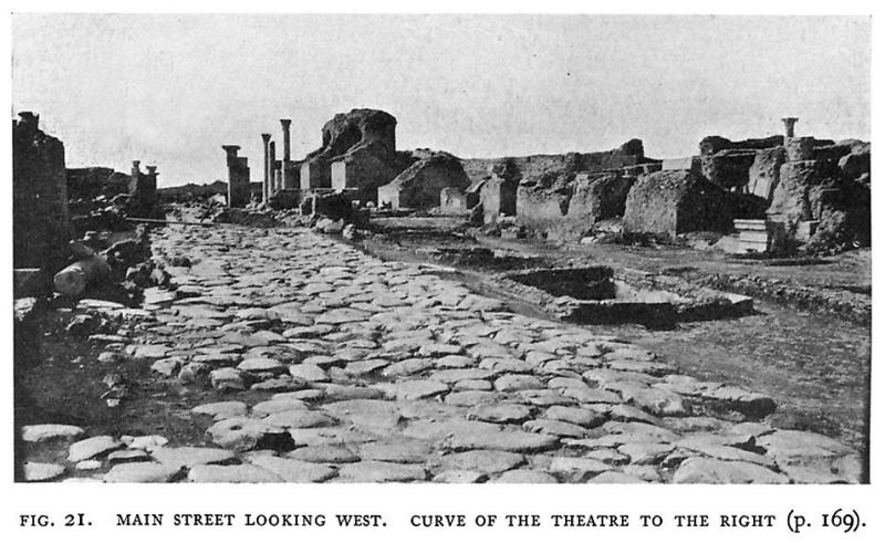
Sepolcri, plan, no. 1), and the tombs are arranged on each side of both roads, though the excavations have been mainly concerned with the space between them. The left-hand road was believed to be the Via Ostiensis until Professor Vaglieri found the true road (plan, no. 5, and figs. 21 and 22). The tombs which flank the latter on the left have been entirely cleared by him; while those on each side of the other were excavated in 1855, but have been further investigated recently. They present a considerable variety of types and periods. Below them all have been found burials in the sand, not dateable earlier than the third century B.C. A few of the tombs at an intermediate level seem to belong to the republic, but the majority are columbaria of the early empire. Most of them
lie below the level of the road, which was raised several times; they are small chambers, round which are niches, giving access to the cinerary urns, which are built into the wall. An inscription under the niche generally gave the name of the person whose ashes were placed there. Those who could afford it had instead beautifully carved cinerary urns in white marble. Scanty remains of elaborate decoration in stucco and of fine mosaic pavements remain; the brickwork, in some cases covered, in others left exposed, is remarkably fine; but, owing to the fact that most of the tombs were used over again for inhumation burials in the third century after Christ, none of them are so well preserved
167
as those of the Via Severiana. Of these later burials some were in marble sarcophagi, others in compartments separated by thin walls inserted in the earlier tombs. It would be unnecessary and wearisome to describe them in detail.(1) Among the sepulchral inscriptions found in this group of tombs we may note that of the unknown soldier of the sixth praetorian cohort (p. 158) and that of L. Domitius Fabius Hermogenes, which has been restored and re-erected in position. He was decurio, flamen divi Hadriani and aedile at Ostia, and died during the tenure of the latter office. His father
gave 50,000 sestertii to the municipality as the capital to provide an annual donative on his birthday of 5 denarii to each of the 110 decuriones, and to other officials. An equestrian statue was erected to him in the forum at Ostia, the inscription on which is almost exactly identical with that on his tomb.(2) He began his career at Rome as a scriba aedilium curulium, but belonged to the order of the knights.
(1) cf. Paschetto, op. cit. 441, ff. and Not. Scavi.
(2) C.I.L. xiv, no. 353; Not. Scavi, 1910, 13.
168
The tomb itself is built over a round tomb of the republican period. The tombs extend almost up to the city walls.
Just before the Via Ostiensis reaches the gate, a cross-road (plan, no. 4) diverges to the left to join the branch road of which we have spoken; while on the right (plan, no. 7) is the base of a statue still in situ, bearing the following inscription: SALUTI CAESARIS AUGUST(I) GLABRIO, PATRONUS COLONIAE, D(ECRETO) D(ECURIONUM) F(ACIUNDUM) C(URAVIT). Which of the Acilii Glabriones this is, is much disputed. Here, too, is one of the cippi of Caninius.
PORTA ROMANA.
The gate itself (plan, no. 8) occupies the site of the original gate, but the level of the street has been raised by four or five feet. The tufa piers have been refaced with travertine, and marble decorations have been added, so that its width was reduced to 17 feet. The left-hand side of the gate has been left as in the republican period, while the right shows it as it was under the empire. Of the remains of the city wall (plan, no. 6) we have already spoken (p. 155), under the empire they passed out of use and were never restored. A few yards to the south is the opening, hitherto believed to be the Porta Romana; the continuation of the wall beneath, however proves the opening to have been made in imperial times. Probably it was constructed to relieve the pressure of traffic that must have passed along the Via Ostiensis. It will be noticed that the two roads are united by a large open paved space not far within the city (plan, no. 11) formed by the demolition and filling up of earlier buildings. These included an open tank with paved approach, subsequently replaced by a large open trough, 70 feet by 12 feet (plan, no. 10), fronting on the main road, supplied from a cistern which also fed a fountain (plan, no. 3) on the branch road.
Close to this trough have been re-erected two fragmentary inscriptions which were no doubt originally set up in duplicate on each side of the attic of the main gate. They record the construction of the gate by the senate and people of Ostia, and its restoration by one P. Clodius Pulcher.
Here was also found the splendid marble Athena Nike (plates XI and XII) which, together with a "pendant" now lost, probably formed part of the decoration of the gate.(1) This is undoubtedly the finest piece of sculpture discovered in the recent excavations, if not the finest that the soil of Ostia has ever produced. The goddess stands full to the front, and is draped except for the arms: she wears a helmet, and has a shield with the Gorgon's head upon it; the right
(1) The statue is fully dealt with by Savignoni in Ausonia, v (1910), 69, ff. Mrs. S.A. Strong had suggested the same identification independently in her lectures.
169
arm hung by her side, the left was raised and probably held a garland; she stands on the right foot, while the left is raised. The execution shows that the work belongs to the end of the first or the beginning ofthe second century A.D. but it is derived from an original of the fourth century B.C. The type, a winged Athena, has been found on vases, cistae and coins, but, of sculptures on a large scale, only two examples of the type had previously been found, at Bulla Regia in North Africa.
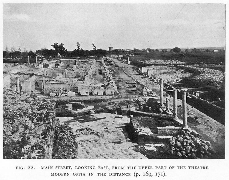
THE DECUMANUS AND BUILDINGS ADJOINING IT.
The "Via dei Sepolcri" now diverges still further to the left; it had already been cleared as far as the next cross-street from the decumanus or main street (plan, no. 16),(1) and two others branching southwards from it have also been found, one outside, one inside the walls. Between it and the main street is a large building not yet investigated, work having, so far, been practically confined to the district between the decumanus and the river. The modern road running to the south and then to the west of the site (passing nos. 53, 51, 50, 49 on the plan) marks roughly the outlines of the city itself, though its outskirts extended even further, especially along the ancient coastline, which has an almost continuous chain of remains of villas as far as Tor Paterno.(2) We may fairly estimate the total area excavated at not more than one-sixth of the whole.
The warehouses of the republican period (plan, no. 13) on the right of the decumanus were never accessible from the street, as has already been pointed out (p. 156). Just beyond them there was a similar building, in brickwork of the early empire, consisting originally of a central corridor, with rooms on each side, which again was only accessible from the north or from the ends (plan, no. 15). Here, however, the procedure adopted was different. When the level of the street was raised some four feet, and the street itself widened, the rooms on the side towards the street were suppressed; the central corridor became a portico opening on the street, nearly six feet above its former level, and the rooms on the other side of it remained, but were similarly raised. They have not yet been entirely cleared. One of the chambers near the middle cippus of Caninius (plan, no. 14) was paved with a fine mosaic, and perhaps became a sanctuary.
The portico presently became more magnificent: the lower story consisted of massive pilasters of brick, with bases and capitals of travertine,(3) while the upper was supported by granite
(1) It was cleared by Prof. Vaglieri. There are small chambers on each side, much altered in late times. At A is a chapel arranged like a Mithraeum, in which, however, dedications to Jupiter Sabazius and the numen caelestis were found (Vaglieri in C.R. Ac. Inscr. et Belles Lettres, 1909, 184).
(2) Lanciani in Mon. Lincei, xiii (1903), 133, ff; xvi (1906), 241, ff.
(3) Below were found traces of earlier travertine pillars with steps between them.
170
columns. Between it and the street was an area occupied partly by small fountain basins, and partly by low walls which probably belonged to booths. At an unknown period, however, these were destroyed and the whole levelled.
THE WATER SUPPLY.
All along the line of the main street, so far as it has been excavated, a large lead waterpipe, one foot in internal diameter, has been found, though in some places pieces of it had been removed in antiquity, after the water supply had failed. It bears at frequent intervals the inscription: COLONORUM COLONIAE OSTIENSE (sic); in one place, however, opposite the Via della Fontana (plan, no. 22) we find the inscription: C. CAESAR AUG. GER(MANICUS); while in another, outside the gate we find instead Q. VERGILIUS TI . . . I . . . . VUS (or UUS), and on the other side IMP. DOMITIANO X COS. (A.D. 84). Vaglieri infers (1) that the pipe was originally laid by Caligula, and that in A.D. 84 it became the property of the community.
The supply was of course distributed all over the city by numerous branch pipes, of which many have been found; and it no doubt fed the great reservoir under the palaestra. The water came from the so-called Monti di S. Paolo: remains of the aqueduct which brought it are indicated in the map of 1547, and to a less degree in that of 1557, all the way from Malafede to Ostia, a distance of about 5 miles. The arches were apparently preserved at that time, and scanty traces of them are still to be seen along the left-hand side of the road. They were constructed of brick-faced concrete; a fragmentary brickstamp which I found among their ruins perhaps belongs to the time of Hadrian.(2)
Behind the colonnade is the opening of the street leading to the barracks of the vigiles, called, for convenience "Via del Vigili" (plan, no. 18). Even after its construction it was not at first open at the south end except by a narrow footway, the rest of the space being occupied by a shop.(3)
THE THERMAE AND PALAESTRA.
On the west of the Via dei Vigili is the main entrance to the thermae and palaestra, by a doorway with the decorations in cut bricks (plan, nos. 17, 21). These occupy a whole block, surrounded by streets on all four sides.(4) The arrangement is by no means normal, the palaestra taking up a considerably greater
(1) Not. Scavi, 1911, 46, 321.
(2) In some alterations to the road at the top of the Monti di S. Paolo, the channel of the aqueduct was found 50 feet deep beneath the surface, with two shafts leading to it (Tribuna, 13th Dec. 1912).
(3) Not. Scavi, 1911, 91.
(4) An incomplete plan is given by Paschetto (pp. 266, 267).
171
part of the building than usual. A small room on the left, perhaps a porter's lodge, has a mosaic pavement representing a scene on the Nile. From the entrance corridor we reach a large hall, 61 feet by 35, paved with mosaic, with black figures on a white ground. Neptune is represented in the centre, driving four hippocampi; the artist has omitted not only the biga, but the whole of Neptune's right leg from the knee down, thus producing a curious effect: all round are marine animals, Tritons, etc.(1) (plate X). A smaller hall to the south has Amphitrite riding a seahorse in the centre, with Hymen preceding her, and a Triton on each of the four sides. To the north is another large hall, the frigidarium, 40 feet by 33, with a similar mosaic, with Tritons, Nereids, and cupids riding marine monsters and fish; at each end is a piscina or bath, lined with marble, with steps leading into it. A door on the west gives access to several rooms heated by hypocausts and used for hot baths; to the east and west of them are the two praefurnia. At the northeastern angle is a cold-water cistern with stairs up to it and, near by, another for hot water. Here we may note not less than five different periods of construction in brick-faced concrete of the imperial epoch, showing the frequency of the successive alterations in the plan of the buildings which occupied this site. To the west of the large entrance hall are two chambers, the northernmost of which has its walls towards the palaestra almost entirely razed to the ground. The mosaic pavement represents boxers, and serves to identify the use of this large peristyle, which is further indicated by the existence in the centre of blocks of stone with holes which served for fixing the apparatus necessary for exercises. To the north of this room are open baths, probably accessible directly from the palaestra, as they lie just to the east of the palaestra court.
We have already alluded to the large reservoir lying under the courtyard of the palaestra and belonging to an earlier period. It consists of five chambers, intercommunicating by narrow openings in the party walls, and lined with hard cement, each 13 feet wide, 6 1/2 high, and at present about 93 feet long. These are cut at the south end by a brick wall. The reservoir could be approached by stairs on the north, which were closed at a later period. A drain was then constructed, perhaps as early as the beginning of the second century A.D. which itself cuts through an ancient limekiln, well below the level of the palaestra. In the room adjacent to the stairs is a large bronze tap, nearly 2 feet high, on the lead pipe by which the cistern could be emptied.(2)
On the north side of the palaestra the peristyle runs right up
(1) See G. Calza in Boll.d'Arte, v (1912), 199.
(2) Not. Scavi, 1911, 262, 452.
172
to the street wall, but on the west there is a row of chambers; at the north-west angle is a well preserved latrine, and in the centre a room with a wide opening and a base for a statue against the back wall. In this room was found a beautiful statue, about 6 feet in height, probably representing Sabina, the wife of Hadrian, still young, holding in her left hand poppies and ears of corn, the attributes of Ceres (plates XIII and XIV). A statuette of a boy genius with the cornucopiae in his left hand, and fruit in a fold of his mantle, was also found here. On the south is a line of rooms presenting no special characteristics. Back to back with them are shops opening on to the portico on the north side of the main street.
The inscriptions which have hitherto been supposed to refer to these baths seem to belong instead to the tbermae maritimae, and we are therefore without definite information as to.the date of their construction. A slab of marble was found in the peristyle bearing a dedication to Lucius Verus, made on 19th September, A.D. 145, the birthday of Antoninus Pius. This must have stood on the pedestal of a statue.(1) It gives us a chronological limit, while from the style of the brickwork and of the mosaics and other considerations, we may attribute these baths to the earlier part of the second century after Christ.
The baths are separated on the north from the barracks of the vigiles (plan, no. 19) by a narrow street, the Via della Palestra (plan, no. 20). The main entrance to this building, as to the thermae, was on the west side of the Via del Vigili. On its east side, not yet excavated, are the remains of private houses. At the north-east corner of the thermae, on the west side of the Via dei Vigili, is a fountain, consisting of a reservoir measuring externally 11 feet long and 6 feet wide, with a vaulted roof. The pipes for filling and emptying it are preserved: at the north end is an opening nearly 3 feet wide for ladling out the water; a hole on the east for a tap was afterwards filled up with cement. A smaller but almost exactly similar fountain stands at the north-west angle of the building, and gives its (modern) name to the Via della Fontana.
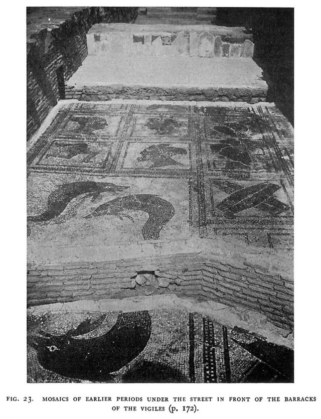
We have already seen (p. 158) that, before the construction of the barracks of the vigiles and of the street by which its main entrance was approached, the site was partly occupied by thermae, which from a brickstamp may be attributed to the middle of the first century after Christ; remains of them have been found under the street, and include an extremely fine mosaic, measuring 43 by 30 feet, in black and white. It has a key-pattern border within which are squares, eleven one way, six the other. The external squares are occupied alternately by crossed shields and by rectangular meander patterns, but the 14 central squares are differently treated.
(1) Eph. Epigr. ix, no. 448.
173
174
The six in the centre give place to a single large compartment, rather badly damaged, in which are four dolphins or other fish, while the four at each end of this rectangle are occupied by four pairs of heads, male heads representing winds, and female heads representing provinces, characterised by emblems. Sicily is indicated by a gorgon's head in the centre of the triquetra. Spain by a wreath of olive leaves, Africa by the trunk and ears of an elephant projecting from the kerchief which covers her hair, and Egypt by a crocodile.(1) Fig. 23 shows a part of the mosaic, as seen from the south.
The building is cut through by the street drain, roofed with tiles, on which have been found 34 brickstamps of the last quarter of the first century A.D.(2) so that the date of the construction of the street is fixed. The pavement has been left in place over the drain, but removed elsewhere so that the mosaic remains visible.
THE BARRACKS OF THE VIGILES.
The barracks of the vigiles (plan, no. 19) had been in great part excavated in 1888-1889, and there was less to be done than at the thermae. The whole of the eastern part of the building, however, had remained buried, and has only now seen the light. The building seems to have been originally a private house, with a large peristyle, taken over by the state during the reign of Hadrian, and restored by Septimius Severus. The main entrance is, as usual, of fine brickwork, with the architectural decorations cut out, not moulded. The bricks bear many graffiti, a clear sign that they were not faced with stucco or marble.
In the street, on each side of the door, were small drinking shops, with mosaic pavements, one bearing the inscription: Próklos epoíêsen, another having a crater with the words [PR]OCLUS FECIT M . . . C . . . S(UA) I(MPENSA), while the third has a crater only. The rooms on each side of the entrance were guard-rooms, and several of them have painted or scratched inscriptions of some interest. In the south-east corner is a remarkably well-preserved latrine,(3) in which were found two dedications to Fortune, a little aedicula against the wall, with the inscription FORTUNAE SANCT(AE), and a cippus erected by C. VALERIUS MYRON B(ENE)F(ICIARIUS) PR(AEFECTI) COH(ORTIS) IIII VIG(ILUM), which stood on the right of the entrance. In the peristyle, the roof of which was supported by brick pilasters, are two fountains, one on each side, and at the west end, opposite the entrance, is the sanctuary of the imperial family. The pronaos is decorated with a black and white mosaic representing
(1) See G. Calza in Bull. Com. xl (1912), 103, ff.
(2) The vigiles were first sent to Ostia by Claudius (Suet. Claud. 25), but we do not know where they were at first quartered.
(3) Not. Scavi, 1911, 209; 1912, 165.
175
176
the sacrifice of bulls to the genius of the emperor (1); the shrine itself, raised above the level of the peristyle, is open to its full width (39 feet). Against its back wall is a suggestus, on which stand five altars; on the right is the base of a statue, and there are seven others standing against the pilasters of the peristyle. Of these thirteen inscriptions the earliest is a dedication to Aelius Caesar, the son of Hadrian (A.D. 137), while the two latest were erected in honour of Gordian III and his wife Furia Sabina Tranquillina (A.D. 238-244). What was the fate of the building after this, we do not know: it seems to have been abandoned in Roman times, for it was stripped of the marble which decorated it, and a heap of broken tiles, ready to be removed for some pavement, was found in the vestibule, while some not very late burials were found within the building. There were entrances to the barracks from the streets on the north and south: the rooms on these sides served as quarters for the troops; those on the west, towards the Via della Fontana, may at first have served as shops, for it appears that it was only in the time of Septimius Severus that the doors and windows were filled up with walls pierced by narrow windows, such as are found in the Praetorian camp at Rome.
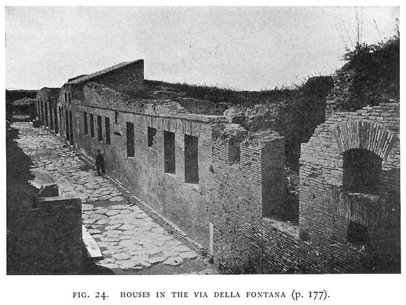
BUILDINGS IN THE VIA DELLA FONTANA.
The street on the north of the barracks has now been entirely cleared, and on the north side of it is a fuller's establishment, not yet fully excavated. To the west of the barracks is the so-called Via della Fontana, cleared in 1897 (plan, no. 22), which runs past the palaestra almost as far as the main street, where it ends in a shop, with a mosaic pavement, representing a crater with the inscription FORTUNATUS [CR]ATERA, QUOD SITIS, BIBE. Vaglieri expands thus: "'hospes,' inquit Fortunatus, 'vinum cratera quod sitis, bibe'"; but I should rather be inclined to suppose a nominative for a vocative, and take cratera as the Greek form of the accusative, and translate "Fortunatus, drink the bowl, because you are thirsty." In any case, there is no doubt as to the character of the shop. The fountain from which the street takes its name has been already mentioned. It is only 4 1/3 feet in length, and is very well preserved, having an aperture for dipping at one end, and two jets for water at the side with slabs of travertine to take the drip, hollowed out to support vessels which had no feet.
On the west side of the street is a narrow block of buildings, extending as far as the street to the east of the theatre. Opposite the entrance to the barracks are some chambers which have been used as cisterns at a later date; but to the south, opposite the
(1) It is carefully described by Carcopino, Mélanges, xxvii (1907), 227,ff.
177
fountain, is the beginning of a house, which is interesting as belonging to a type found elsewhere at Ostia, e.g. opposite the entrance to the thermae. It is entirely different from the traditional Roman house, and approximates to the modern type.(1) Here there is no vestibule, atrium or tablinum: there is a single line of rooms on the ground floor, looking on to the street, with numerous windows, and stairs leading up to another floor. One of the rooms was originally reached from the street, but was closed later on, a window being left, which was glazed with sheets of mica. The walls are decorated in a style resembling the second Pompeian style, with
figures in large red and yellow fields, and architectural framework. There is a curious avoidance of the horizontal line, which appears to be intentional, and is perhaps an attempt to obtain a correct perspective. The flat ceiling is formed on a framework of canes, and continues the design of' the walls; and it has been possible to restore it. The next room has "impressionist" landscapes in small panels.
To the south of this house covered passages lead into the street
(1) Paschetto, p. 428. Some of the recently found houses consisted of distinct "apartments," with separate staircases and approaches.
178
running to the east of the theatre. Further south again are some well preserved examples of shops (plan, no. 24): the travertine thresholds have a channel for the planks by which they were closed, a small door turning on a hinge taking the place of the last plank. A mass of brickwork in the angle is the beginning of a staircase which was continued in wood, and led up to an upper chamber, probably a bedroom; its wooden floor was supported on a brick cornice 15 feet from the floor, and it was lighted by a window over the door.
THE THEATRE.
The next group of buildings is formed by the theatre and the open space (a garden) to the north of it (plan, nos. 28-31 and fig. 26). On the north and east of it are streets, but not on the west; while the external corridor of the theatre extends southward as far as the main street. The ruins of the theatre have probably always been recognisable, as, owing to their height, they have never been entirely covered; but the building was not excavated until 1880-1881, and the stage has been further investigated recently. The origin of the building dates from the time of Augustus, and a fragmentary inscription GRIPPA . . . . . COS. was found near the scena. The remains of the original building, in concrete faced with opus reticulatum and in opus quadratum, lie rather more than 2 feet below the later level. The first restoration occurred under Hadrian, to judge from the dates given by brickstamps; the second was due to Septimius Severus and Caracalla, in A.D. 194; while the third was made at the end of the fourth century, 16 marble bases from the open space to the north having been used in strengthening the walls of the central corridor. The theatre is about 300 feet in diameter. The cavea is much ruined. The upper tiers of seats were reached by staircases opening on to the external portico, the orchestra not only by the usual passages on each side of the stage but by a central corridor leading in directly from the south.
Recent excavations have revealed traces of the arrangements for the curtain, but one must await the publication of the final reports before speaking of them in detail, as the work is not yet entirely complete. It would seem that the stage of the first theatre went further to the north: the external portico with arcades is certainly an addition to the original plan, belonging probably to the time of Hadrian, as is indicated by the fine brick cornices. The access to the arcades was regulated by an iron railing, traces of which, with the pillars which supported it can be seen on the travertine pavement of the surrounding area. The arcades in turn gave access to the steps to the upper seats, while the chambers between these staircases were used as shops, some of which were in later times converted into cisterns: in one of them were found some 40 bodies, possibly of men-at-arms of the sixteenth century.
179
Fine remains of the marble decorations at the theatre, some attributable to the period of Hadrian and others to that of Severus, have come to light, together with numerous fragments of sculptures. Of the second story of the portico nothing remains but a few pieces of the brick cornice.
The trapezoidal space between the theatre, the main street, and the buildings to the east (plan, no. 23) was occupied by a colonnade constructed at the expense of earlier buildings, including a fountain and a latrine. At a still later period, when the ground level had already risen considerably, a mediaeval oratory (plan, no. 25), of which but little traces remain, was built close to this colonnade. Numerous classical sarcophagi were found here, apparently used for later burials. The oratory itself may be associated with the martyrdom of the companions of Quiriacus,(1) who met their death in A.D. 268-270 ad arcum ante theatrum. One of the sarcophagi, of Christian date, bearing a representation of Orpheus, had as its cover a slab bearing the words HIC QUIRIACUS DORMIT IN PACE, though whether this was the bishop or no, it is impossible to say. On the south side of the road are the remains of two republican monuments (plan, nos. 26, 27) of which we have already spoken.
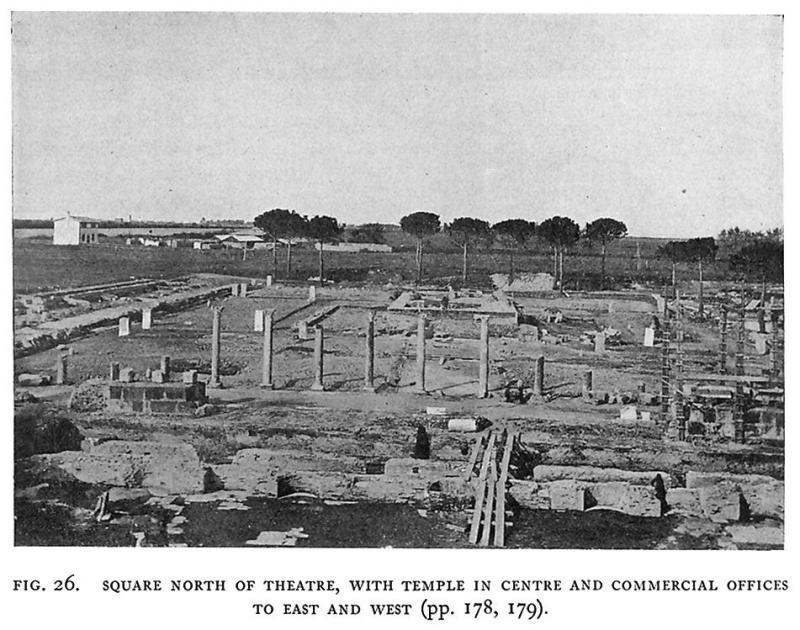
OFFICES OF COMMERCIAL CORPORATIONS.
The area to the north of the theatre (plan, no. 29, and fig. 26) is a square measuring 262 feet each way. On the south is a line of marble columns,(2) while on the east and west there were brick columns covered with stucco, of which few traces remain. Behind these last, on the east and west sides, there is a line of small rooms (plan, no. 31) with seats round the walls, serving as the offices of various commercial corporations, their names being usually given on the mosaic pavements of the rooms or indicated by signs. The chamber at the south-east corner was almost certainly the office of the sacomarii or weighers, for in it was found the splendid altar with reliefs representing the origins of Rome,(3) dedicated to the genius of the corporation, or of the weigh-house, on 1st October, A.D. 124. The inscription VOTUM SILVANO was added later, as a dedication to their protecting deity. The second chamber going northwards belonged to the pelliones or tanners of Ostia and Porto; the third to the navicularii lignarii, the boatmen who transported timber to Rome; the fourth to the NAVICULARII(?) . . . . ARRIC(INENSES ?), the fifth to the measurers of grain, as is shown by the
(1) According to the Martyrologies, the first bishop of Ostia.
(2) On one of them is cut in relief an aedicula with a genius sacrificing, and the inscription: Genio kastrorum peregrinor(um) Optatianus et Pudens frum(entarii) fratres ministerio / / / / / votum solverunt (C.I.L. xiv, no. 7).
(3) P. Ducati in Mélanges, xxvi (1906), 483; Strong, Roman Sculpture, 241, pls. lxxiii, lxxiv.
180
representation of a man kneeling down beside a modius or bucket measure with the levelling staff in his hand. Others, more recently discovered, belonged to the navicularii Misuenses (Misue, near Carthage), to the navicularii Musluvitani and Sabratenses(1) and the stuppatores restiones, dealers in rope and tow. The pavements of the offices of these shipping corporations are decorated with ships in full sail entering the harbour, and one of them has a rough representation of a lighthouse. On the west the mosaics are more mutilated, but from the emblems it is clear that here too were offices, belonging to corn measurers and shipping corporations. In one we see two palm trees figured with an amphora between, and in another a lighthouse in four tiers, with ships around.
The rooms themselves are very small, and were possibly only the business offices of these important corporations, which may have had larger halls of their own for banquets or assemblies, or may have held their meetings in some public building.
THE TEMPLE OF CERES.
The centre of the open space is occupied by a temple facing south (plan, no. 30) like the other temples of Ostia. Of this there are only scanty remains. It was a temple in antis with two columns, on a podium 7 feet high approached by several steps; some remains of the cornice have been found but the whole of the superstructure has been destroyed. It is generally called the temple of Ceres: this is only a conjecture, but the existence in the porticoes by which it is surrounded of the offices of many of the corporations concerned with the importation of grain lends weight to the suggestion.(2) From the remains of marble gutters found in it, the space surrounding the temple appears to have been laid out as a garden. Here have been re-erected the sixteen bases of statues, all bearing inscriptions set up by various corporations in honour of their benefactors or prominent members(3): these probably stood here originally, but had been used in a late restoration of the theatre.
A PRIVATE HOUSE.
The space to the west of the western line of rooms has not yet been excavated, except near their south-west angle. Here a small private house has been found (plan, no. 32), the only example so far found in Ostia of the Pompeian type. It possesses an atrium with an octastyle portico enclosing a marble-lined impluvium; several of the rooms have fine mosaic pavements, mostly with marine
(1) Musluvium was in Mauretania Sitifensis, but the reading of the inscription is doubtful. Sabrata was also in N. Africa.
(2) Note that in C.I.L. xiv, 409, the mensores frumentarii have the epithet Cereris Augustae.
(3) Paschetto, 335, ff.
181
scenes. The name of L. Apuleius Marcellus, found on a lead pipe leading towards the house, has been given to it for this reason.
THE MITHRAEUM.
To the west is a well-preserved Mithraeum (plan, no. 33), which was approached both from the house and from outside: it was indeed probably a room belonging to the house and adapted for the purpose. The sanctuary proper is of the usual type. The central passage and the podia on each side are covered with white mosaic, and are now protected by a roof. The podia are 32 feet long, and the central corridor is about 6 feet wide, so that about 40 people could use the sanctuary, kneeling on the podia at each side, so as to leave the corridor clear. On the floor of the central passage is the inscription in mosaic, twice repeated, SOLI INVICT(O) MIT(HRAE) D(ONUM) D(EDIT) L. AGRIUS CALENDIO. Three statuettes of dadophori found here are now in the Lateran museum; while of the group of Mithras and the bull only fragments were discovered. The altar at the north end, above which it stood with a flight of steps leading up to it, is still in position, with the inscription C. CAECILIUS HERMAEROS ANTISTES HUIUS LOCI FECIT SUA PECUNIA. In the pavement of the corridor near the door is a round hole which may have received the blood of the victims: in the mosaic close by is figured a knife, while further on are seven semicircles, representing the seven celestial spheres, corresponding to the six planets (which are represented on the vertical sides of the podia by the figures of divinities) and to the Sun himself, doubtless represented by a relief of Mithras slaying the bull at the further extremity: at the ends of the podia facing the entrance are figures of dadophori: on the top of the lower section of the podia are the signs of the zodiac.(1) In an adjacent room there was found a niche with the figure of Silvanus in mosaic, now also at the Lateran. [Ashby has merged two mithraea: The Mitreo delle Sette Sfere, which he is describing, and the Mithraeum in the Palazzo Imperiale, which was apparently not accessible; L. Agrius Calendio and C. Caecilius Hermaeros belong to the latter mithraeum, near which a figure of Silvanus was found; the round hole, the knife, the seven semicircles and the signs of the Zodiac do belong to the Mitreo delle Sette Sfere; JThB]
FOUR SMALL TEMPLES.
To the south is the group of four small temples already mentioned (p. 157), standing side by side on a single base. They were each tetrastyle, and symmetrically constructed; and the hypothesis of Carcopino that these are the four temples of Venus, Fortune, Ceres and Spes, constructed by the first Gamala in the Augustan period, is very tempting.(2) In one of them, the eastern-
(1) For a more detailed description see Paschetto, op. cit. 394, ff. The missing relief of Mithras, if we accept the supposition that this is the Mithraeum excavated by Petrini in 1802, is in the Galleria Lapidaria at the Vatican (no. 144a).
(2) C.I.L. xiv, no. 375; Mélanges, xxxi (1911), 224, ff. (see p. 157 above and note). Van Buren follows Mommsen in thinking that there was only one Gamala, who lived under Hadrian, and did not construct, but restored, the temples.
182
most, was found an altar with a dedication to Venus, of the second century after Christ (second half ?), and we know (1) that the younger Gamala restored the temple of Venus. The third temple from the east has a mosaic pavement, bearing an inscription recording its construction by various officials of Ostia, probably in the time of Augustus.
In front of these temples lay an open space, reaching almost to the main street. On the west side of this space were a nymphaeum and a small temple of Juppiter. In the nymphaeum was found a fine portrait, in half-relief, of a man in the act of sacrificing. The temple of Juppiter is remarkable for the delimitation of its "area," which seems to have been carried out before its construction by the erection of four cippi, each inscribed i o m s (Iovi optimo maximo sacrum); these were left standing under the angles of the building erected above them. The excavation of the main street itself is now being rapidly carried towards the great temple, and shops and statues are being unearthed.
As has been already stated, the area now occupied by the Mithraeum and the so-called house of Apuleius Marcellus originally belonged to the precinct of the temples, and was enclosed by a wall in opus reticulatum. To the west of the four temples is a large building supposed to be a tannery, containing a number of basins of various sizes. At the west of this is a street, about 12 feet wide, on the west side of which is a portico formed by a series of walls, with intervals between them, but with continuous foundations, so that the intervals were probably filled by railings. Behind them is a walk entered apparently only from the south end, leading to a row of chambers parallel to the street. Ten have been excavated so far, and there may be more to the north; they were probably shops (plan, no. 35). Their front walls (and perhaps the back wall also) are built of opus quadratum of tufa blocks, and so is the end wall of the southernmost, which is larger than the rest; it is, further, supported by three buttresses of the same material; the dividing walls, on the other hand, are of brickwork. It has therefore been believed that the difference of material connoted a difference of date, and that an original structure of opus quadratum, possibly a republican cistern,(2) was later on broken up into a number of shops; but there seem to be no grounds for supposing that the stonework is in reality any earlier, and a better explanation is that the stonework was used because special solidity was desired; possibly because the contents of the building were of value. Behind these is another row of shops of later date, originally no doubt not
(1) C.I.L. xiv, no. 376.
(2) Against the south wall stands a cippus with the inscription aquaeductus per p. p. p. p. - perhaps puteum publicum - (C.I.L. xiv, no. 4147).
183
184
connected with them and opening on to another street. Here, however, a considerable extent of the site remains entirely unexcavated.
GRAIN AND OIL MILLS, ETC.
At some distance west we reach a building (plan, no. 36) containing a series of mills for grain and oil, still better examples of which may be seen in Pompeii. As there, the floors are paved with blocks of lava (selce), horses having been used to turn the larger mills. To the west of this building ran a street 20 feet wide, not shown on our plan,(1) with shops on its west side, which has not so far been cleared to any great distance. The northernmost room (plan, no. 37) on this side is a large one, and contains 35 dolia buried in the ground, several of which had their capacity, which varied from 28 1/2 to 47 amphorae, marked on the lip. Inside them were found about four hundred flat terra-cotta moulds, representing scenes in the circus, which, it has been conjectured, were used to make the loaves distributed at the games.
To the north is the so-called Casone del Sale, now the office of the director of the excavations and to the south is a house (plan, no. 38) consisting of eight rooms on the ground floor and five on the mezzanine, not arranged round a courtyard, but leading into one another, and lighted by numerous windows on the east side; one of the largest and highest has two rows of three windows which looked into a lane or garden. Several of the rooms on the ground floor have attractive paintings, now unfortunately somewhat damaged by the weather.(2)
To the south of this house are others, all of them entered from a street on the west, which at its south end falls into the street running round the temple (plan, no. 40).
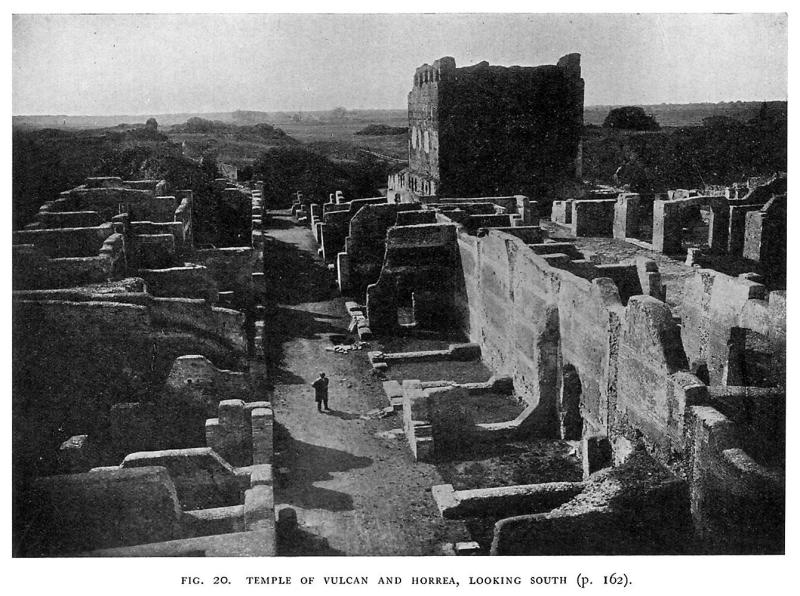
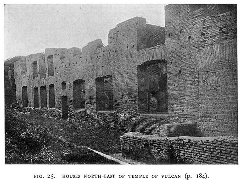
TEMPLE OF VULCAN.
The fact that this street resumes its previous line on the west of the temple, and that this line coincides with the back of the stage of the theatre, may indicate that the temple is of comparatively recent origin, and that previously the road ran straight. Or, having regard to the fact that it also stands in the line of another important street (plan, no. 39), we may prefer to consider that it was purposely placed at the point of this intersection. Certainly the temple (fig. 20) as it stands belongs to the first half of the second century A.D. It rises on a very lofty base, supported by vaulted substructions, so that
(1) Paschetto, pp. 239, 343.
(2) cf. Paschetto, p. 423. The whole of the group of buildings going westward from this point has been carefully studied by Carcopino, Mélanges, xxx (1910), 397, ff.
185
it is by far the most prominent building of ancient Ostia. It was hexastyle prostyle and faced southwards, but only a few fragments of its columns and of its cornice and frieze remain. The lofty cella, on the other hand, which is constructed entirely of brick-faced concrete, is well preserved. The side walls each had three niches for statues, and at the back is a long podium. The walls were faced with marble, which has now entirely disappeared, but the warm red tint of the bricks is very pleasing to theeye. The marble pavement was preserved to some extent when the excavations were made, but nothing now remains except the huge threshold-block of green africano marble, nearly 20 feet long.
The attribution of the temple has been much discussed; some consider it to be the Capitolium, while others attribute it to Vulcan, who was certainly the most important deity at Ostia, as inscriptions show us. We may note the frequent mention of the pontifex Volkani et aedium sacrarum, who was chosen for life, and was assisted by aediles and praetores sacris Volkani faciundis. The question must at present be left unsettled; but this was beyond doubt the chief temple in Ostia, and in all probability it faced on to the forum, which is thus to be sought immediately to the south of it, and also of the main street. We may note indeed that C.I.L. xiv, 353, found in 1824 "in the forum in front of the temple," is the base of an equestrian statue of Fabius Domitius Hermogenes, erected (as the inscription itself says) in foro, so that its provenance is in all probability correctly given.
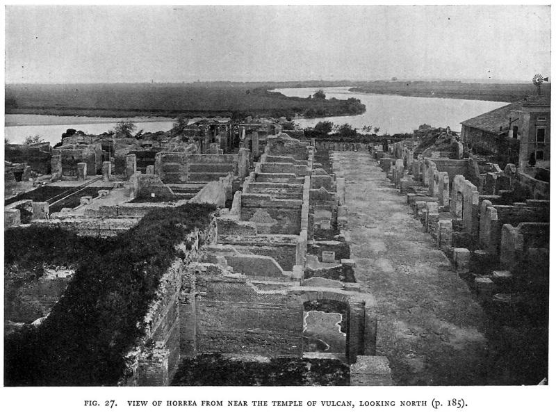
WAREHOUSES AND STORES.
To the north of the temple there runs to the river an unusually broad street, 30 feet across, with arcades on each side, which increase its width to over 50 feet. On each side of the portico, which is paved with herringbone brickwork, are chambers (fig. 27), those nearest to the temple being of specially large dimensions. The rest, fifteen on each side, each measures some 18 feet square. They were used as stores, and were closed with planks in the manner described above on page 178. There were probably more of them to the north, but the river is dangerously near the ruins at this point, and has no doubt done much damage. The wall which now blocks the north end of the street is entirely modern.
Like the shops described above, these stores had a mezzanine floor, reached by a flight of wooden steps; the wooden floor was supported on the brick cornice, at 11 feet above the ground. The construction, of opus reticulatum with brick quoins, is extremely fine. Stairs lead to the upper chambers at two different points on each side; and
(1) Paschetto, p. 357.
186
about the middle, in the line of the road to the north of the barracks of the vigiles, a covered passage leads through, and communicates with the buildings to the west. Here its line is prolonged by a street, the so-called Via dei Misuratori (plan, no. 43), which turns slightly northwards,(1) so as to follow the bend of the river. Taking the first turning to the right, we find ourselves in a short street (plan, no. 42) to the north, towards the river, where its termination is broken off. On the Pompeian principle of nomenclature it has been called Via della Fortuna, from a terra-cotta relief of Fortune on the pilaster at the corner. A colonnade runs along its western
side; while the warehouses on the east are noticeable for the way in which arches, carried by travertine corbels, project over the street above their entrances: these, doubtless, supported balconies. The main street takes its name from the sign of the measurers of grain, the modius and the levelling rod. This is placed over a doorway on the right, decorated in carved brick, and leading into other storehouses.
To the south is the group of buildings known as the Piccolo
(1) Paschetto (p. 309, fig. 72) wrongly makes it quite straight. Carcopino's plan is correct.
187
Mercato (plan, no. 41). The main entrance was on this side, and led into a long, narrow rectangular space, surrounded by a portico giving access to a number of chambers, eleven on each of the sides, and six at each end: these were perhaps shops rather than storehouses, since they were closed by double doors. Between the eastern row of chambers and those on the west of the street leading north from the temple there was a narrow alley. In the centre of the court are two low arches, which may have supported a wooden passage connecting the upper floors of the two sides.
An exit led to the south into the street running round the temple: this continues its former line to the west, with shops on each side, but it has not yet been followed very far. The back wall of those on the north is common to those on the south of the "piccolo mercato": it is an earlier construction of opus quadratum, turning and running to the west of the western outer wall of the "mercato," from which it is separated by a narrow interval. This is perhaps the city wall of the republican period (fig. 19), though it is so thin that it can have been no more than the shell to a bank of earth.
Further west is another building not yet excavated, probably also a part of the commercial quarter of the town. To the west again is a part of the site which, with small exceptions, has hardly been excavated at all. The line of the street has been washed away by the river, whose incursions the earth from the excavations is being partly used to prevent.
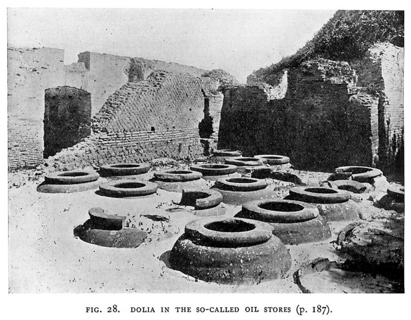
After some distance we reach a building on the river bank and in part washed away (plan, 45), a detailed study of which has been made by Carcopino.(1) The most interesting room contains a group of about twenty large dolia in situ (fig. 28), of a capacity varying from 23 to 45 1/2 amphorae. The building is divided by a passage thought by Carcopino to have been a public thoroughfare.
A little further on we come to the street which followed the windings of the river bank; the buildings on each side of it have not yet been excavated.
THE "PALAZZO IMPERIALE."
After following this road for some way, we reach a large building known as the "Palazzo imperiale" (plan, no. 46). Carcopino (2) considers that there may be a good deal of truth in the chance appellation, for, firstly, it is certain that two lead pipes bearing the name of Matidia were found here in 1863, and secondly, if the Mithraeum in the western portion of the building is the same as
(1) Mélanges, xxix (1909), 360, ff.
(2) Mélanges, xxxi (1911), 219.
188
that searched by Fagan in 1797, then the inscription in C.I.L xiv, no. 66, which speaks of the dedication to Mithras of a "crypta palati concessa a M. Aurelio" [Commodo Antonino Augusto], was probably found in it, and would further confirm the identification. Carcopino holds, too, that the magnificence of the objects found in the building, the fine mosaic pavements (one of which, with geometric designs and arabesques in colour, was transported to the Vatican), and the sculptures, such as the Juno of the Braccio Nuovo (no. 83), and the plan are all indications in favour of his hypothesis. The building, according to him, falls into three parts: (a) the shops or offices on the exterior; (b) a courtyard to the south, which he believes to have been devoted to public uses, as it was distinguished by a sign like those that are found at street corners (this argument is hardly sufficiently strong); (c) the house or palace proper in the centre. As Vaglieri remarks, the whole building has not yet been excavated, and it is therefore difficult to decide. As we enter it from the north, passing through a doorway adorned by two granite columns, we first reach the thermae, grouped round a large hall, from which was taken a large mosaic pavement now in the Vatican.(1) On the east side of it is the piscina, and to the south are other rooms, not yet completely excavated, which were heated by hypocausts.
To the south again is a large peristyle, so far only partially excavated, with a mosaic pavement representing a lighthouse surrounded by a labyrinth enclosed by walls and then a range of rooms, including the Mithraeum mentioned above (p. 181). To the south is another courtyard with rooms to the west of it, while, still further to the south, is an entrance leading to a street going southwards, which has not been followed further.
MISCELLANEOUS BUILDINGS.
To the west of the building last described another narrow street ran south. On the west side of it is a double portico, with brick pillars on the east, and pillars of opus quadratum, with arches springing from them, on the west; behind it are small chambers, backing on to the so-called "Navalia" (plan, no. 48). They consist of three vaulted chambers running from south to north, each about 50 feet long, as at present visible (though neither their north nor their south end has yet been found), and 10 feet wide; they must have been more than twice as long to reach the river, if they ever did so, and how far below the ancient ground level may be, it is quite impossible to say. Above them is a pavement in opus spicatum, with cement above that. According to an assertion by a competent
(1) In the Sala dell' Immac. Concezione (Nogara, Mosaici nei palazzi apostol. p. 35 and pl. lxix, lxx).
189
person, quoted by Lanciani,(1) there had been visible, not very long before, in the wall which supported the bank below this building, two large openings with the thresholds far below the water level, and with slots in the door-jambs. This is, it seems to me, the only serious argument for considering them to be other than mere substructions; but it is impossible to arrive at any definite conclusion without excavation, which must be difficult owing to the proximity of the water level.
To the west is a series of heaps of ruins, which seems to form a semicircle opening towards the Tiber: this has been identified with an emporium supposed to have been constructed by Septimius Severus, but with little or no foundation. Further on again is Torre Bovacciana (plan, no. 49) which is built upon ancient ruins, possibly those of a lighthouse, since it was certainly at the mouth of the river at the time of the empire. Here is the modern ferry, and on the opposite bank too are scanty remains of Roman construction.
To the south-east of Torre Bovacciana, along the ancient coastline, are remains of baths (plan, no. 50) which have so far only been partially excavated. They may be identical with the thermae maritimae, but these should, I think, be sought actually at the so-called Porta Marina (plan, no. 51), which is in reality part of a vaulted hall with four pillars, belonging to some larger building. Only six rooms of the thermae were cleared under Pius IX; most of them were heated by hypocausts, and have well-preserved pavements in black and white mosaic, representing marine scenes and an athletic contest.
Both these groups of ruins are, as we have seen, on the line of the ancient sea-coast, which can be traced south-eastwards as far as Tor Paterno and even further by the sandhills covered with ruins and fragrant shrubs which now lie several hundred yards inland. Behind it ran the coast road, the Via Severiana, once full of life and movement, now given up to solitude and quite obliterated by the sand and scrub. Over it wave the beautiful umbrella pines of Castel Fusano.
Paschetto (2) wrongly attributes to Visconti the statement that the gate by which this road left Ostia had actually been found; all Visconti said was, that if the excavation of tombs along the line of it were continued, the gate certainly must come to light.(3) We do not therefore know the exact extent of the city in this direction.
At the point marked 53 in the plan four interesting columbaria have been found, and two of them have recently, been rendered accessible. The first contained the painting of Orpheus and Eurydice, which, like the other paintings from this group of tombs,
(1) Ann. Inst. (1868), 148.
(2) op. cit. p. 245.
(3) Ann. Inst. (1866), 292.
190
was removed to the Lateran (some are also in the Vatican library), while the second, that of the Claudii, was similarly adorned; the vault indeed is still preserved, with some of the stucco decoration of the niches. The exterior is of fine opus reticulatum and brickwork, which was obviously left visible.
THE METROON.
The only building which has been excavated in the southern portion of the city, the Metroon (plan, no. 52), lies some way to the north-west of these tombs. The group excavated in 1867-1869 consists of the temple itself, which was tetrastyle; only the foundations of the walls were preserved. Behind it was the schola of the cannophori and dendrophori, various inscriptions of whom were found. To the north was a subterranean sanctuary which was in plan very like a Mithraeum,(1) though the mosaic pavement has figures of a man and animals and birds, some of which seem to have no connexion with the cult of Mithras.(2)
In front of the temple was the campus matris deum, a trapezoidal area devoted to the worship of the Magna Mater.(3)
THE HARBOUR.
If we return to Torre Bovacciana and cross the river by the ferry, we find ourselves on the so-called Isola Sacra. Its size has largely increased since Roman times; for then the coastline ran north-west, a little inside the line of the modern road. There are no ruins of buildings along the former shore, but traces of the ancient road have been found, leading from the ferry to the old church of S. Ippolito, on the north side of the island; and close to the church recent works for the regulation of the navigable channel, the Fossa Traiana as it is called, have led to the discovery of warehouses along its south bank, opposite to the picturesque fortified episcopal palace of Porto, now a farmhouse.
The outline of Trajan's harbour is roughly shown in the map of 1557 (fig. 18). The harbour and its adjacent buildings had of course been studied with far greater care and planned with comparative accuracy by Antonio Labacco, who published a plan and description in 1552 in his Libro appartenente a I'architettura. Dupérac attempted a restoration, an engraving of which figures in Lafrèry's Speculum Romanae Magnificentiae (about 1575). The site has never been properly excavated, but Lanciani was able to make careful, though by no means complete observations, when the ground was turned over in 1864-1867, in search of objects of art.(4)
(1) Paschetto, p. 374.
(2) Cumont, ii, p. 414, no. *295.
(3) C.I.L. xiv, no. 324.
(4) See Annali dell' Instituto, 1868, 144, ff. and the plan in Monumenti, viii, tav. 69.
191
Trajan's harbour was a hexagonal basin, entered from the Tiber by a channel a little to the west of the episcopal palace; on the left was a rectangular basin, still visible to the north-west of the modern cemetery, and on the left again the canal leading to the outer harbour of Claudius. This, Lanciani thinks, is a part of the original canal connecting the Claudian harbour with the Tiber, which Trajan was obliged to fill up. On the right is the entrance to the hexagonal basin, now in part blocked up by reeds and rushes, and a favourite resort of wildfowl. The bottom of it is said to be paved with slabs of stone.
Warehouses surrounded the basin on all sides, and their remains may still be seen. To the north-west are ruins of what is supposed to be the imperial palace: a theatre seems to have formed part of it, and behind the stage is a labyrinth of subterranean chambers constructed in very fine opus reticulatum and brickwork, but largely coated with cement, perhaps a reservoir. To the west is a projecting pier, forming the north side of the channel which led out into the Claudian harbour.
As we have seen, the port was protected by walls, probably built in the time of Constantine. In the arrangement of the towers they resemble closely the Aurelian walls of Rome. A gate in the inner enceinte, known as the Arco di Nostra Donna, still stands on the north-east side. A little further on are the scanty ruins of an elegant circular brick building, the so-called temple of Portumnus.(1) For the remains of the other buildings discovered from time to time, reference must be made to Lanciani's plan; the main outlines of the harbour and the various channels can be recognised on the spot and on the Italian staff map, but the main attraction of the site at present is its picturesqueness.
Of the Claudian harbour even less is preserved; its main outlines can be made out from the map before cited; the Monte Giulio marks the north-eastern breakwater, and the Monte Arena, now crowned by a conical shepherd's hut, the central mole. That this was independent of the lateral breakwaters seems clear both from the coins of Nero (2) and from literary evidence (3); but nothing except the beginning of the left-hand breakwater can be seen. The researches conducted on the site by Carcopino were limited to trial pits and soundings (4); they led to the following conclusions: The width of the entrance between the right arm and the central mole was about 125 yards - there were hardly any traces of the left arm, unless at a greater depth than that to which he was able to penetrate, except at the beginning and the end; the position
(1) Papers, vi, 191.
(2) Cohen, 2nd ed. 33-41.
(3) Suet. Claud. 20; Juvenal, xii, 75, etc.
(4) Not. Scavi, 1907, 734.
192
of the latter gave the width of the left-hand entrance as about the same as that of the right hand.
The contrast between the life of the past and the desolation of the present is acute, both at Ostia and at Porto. When one reaches the top of the last hills on either side, and looks down on to the great plain that stretches out to the flat shore, with a sea beyond in which a ship is rarely seen, it is hard to imagine the days when there was at the mouth of the Tiber the harbour of the capital of the world and a great commercial city which depended on its trade. We are better off with regard to inscriptions than on most other sites; Ostia and Porto have so far yielded over three thousand, but we shall learn even more from the ruins themselves. Already Ostia gives us an idea of wealth and. prosperity and activity which we miss in Pompeii, and the strength and beauty of its architecture impress us as much as the profusion of works of art with which it was adorned, specimens of which are to be found in all the museums of Europe. Yet, as will be seen from the examples we have given, objects not less splendid await discovery. We may hope that the excavations may be continued until the whole area is laid bare. Fortunately there are no modern buildings on the site and no great natural difficulties. It is hardly too much to say that Ostia then be one of the most interesting of ancient cities that the world has to show.
IV. A NOTE ON MEDIAEVAL AND MODERN CHANGES IN THE TIBER MOUTH.
In attempting to bring before our minds the configuration of the coast at Ostia in ancient times, it is necessary to recollect that since then the advance of the land has been continuous. The mouth of the Tiber is now about three miles from the nearest ruins of Ostia, which were no doubt at the water's edge at the beginning of the third century A.D. We can, indeed, safely say that the advance has become more rapid during the last few centuries; for the tower of S. Michele, built by pope Pius V in litore maris in 1568, is over a mile from the mouth. The current along the coast runs from south to north, so that the greater part of the solid matter brought down by the river is deposited to the north of the mouth.(1) There seems, therefore, to be little doubt that Claudius and Trajan made a fatal mistake in constructing an auxiliary port on the right bank of the Tiber, instead of on the left, though their object in doing so
(1) Paschetto, fig. 1.
193
was clearly to avoid the dangerous southerly winds. The evil alluded to has very likely increased since the opening of the channel which led from their harbours upstream into the Tiber, and downstream into the sea, thus creating an island and dividing the force of the current. The authors of the recent proposal for the construction of a ship-canal to Rome, which would not be a very difficult matter, have therefore proposed to place its outlet at that of the "Stagno,"(1) to the south of Ostia, where the coast has only advanced 600 feet since Roman times. It is at the main mouth of the Tiber that the coast-line advances the faster; and, partly for this reason, and partly because the distance is shorter, the northern arm of the Tiber is at present used for the entrance of what little river navigation there is. Ships of any size, however, must discharge their cargo at the small village of Fiumicino ("little river" - the name really belongs to the navigable arm). This was only built in the nineteenth century, though the channel was repaired under Gregory XIII (1572-1585), filled up again by the flood of 1598, and reopened by Paul V in 1612. Even here there are difficulties owing to the smallness of the tide (about 1foot), which permits the formation of a bar.
It is further necessary to remember that the course of the Tiber above Ostia was completely changed by the great flood of September, 1557. Previous to that time, as is shown by the map of the Campagna of 1547, the river took a great bend towards the south-east, about a mile and a half above the castle: it then made an almost complete circle, passing the castle, the site of which had been carefully chosen a little above the point where the bend ceased, and running westwards from it past S. Sebastiano until it reached its present course close to the Casone del Sale. The same state of things is shown in the map of 1557 (fig. 18). But, by a tendency which the Tiber manifests above as well as below Rome, the two reaches, in which the river is running in opposite directions, tended to approximate: the maps show us that by 1547 the barrier had become extremely narrow, and in the flood of ten years later the river simply cut across the neck and deserted its old course for ever, leaving the castle nearly a mile inland. This change in its course produced another, which has been a source of much difficulty at the present day. Instead of running past the ruins of Ostia in a direction more or less parallel to the Via Ostiensis, it reaches them after a southward course of
(1) The "Stagno" or lagoon marked in the renaissance maps may well have been a part of the ancient salt-marshes: and in any case there was a bridge over the channel which led from it into the sea; this bridge, as an inscription tells us (C.I.L. xiv, 126), was restored by Carinus and Numerianus, and we gather that it marked the boundary of the territory of Ostia towards that of Lavinium. The inscription speaks of Laurentes: but Laurentum had in imperial days disappeared, and its cults had been absorbed by Lavinium, while its place on the coast was partially taken by a village called Vicus Augustanus Laurentium (which did not occupy the same site) with a municipal organisation of its own. But the name Laurentes probably embraces the inhabitants both of the Vicus and of Lavinium: the inhabitants of the latter are generally called Laurentes Lavinates.
194
about three miles, and then turns sharply to the south-west just at the Casone del Sale; thus the erosion is very strong, and a considerable part of the warehouses on the bank of the river has actually been washed away. The earth from the present excavations isnow being used to protect the site against further damage. The mediaeval salt marshes, which only ceased to exist in the 'seventies of the last century, lay between the road and the river, and did not apparently extend beyond the Fiume Morto (the dry bed of the Tiber), even after the change of the course of the river in 1557. Dionysius tells us that Ostia was placed by Ancus Martius in the angle between the river and the sea,(1) and his description is certainly easier to understand when we know the previous course of the river, though there is nodoubt that the circular bend shown in the map of 1557 has been accentuated considerably since Roman times, inasmuch as it cuts into the line of the Via Ostiensis, which ran absolutely straight for the last few miles of its course.
(1) Dion. Hal. iii, 44.
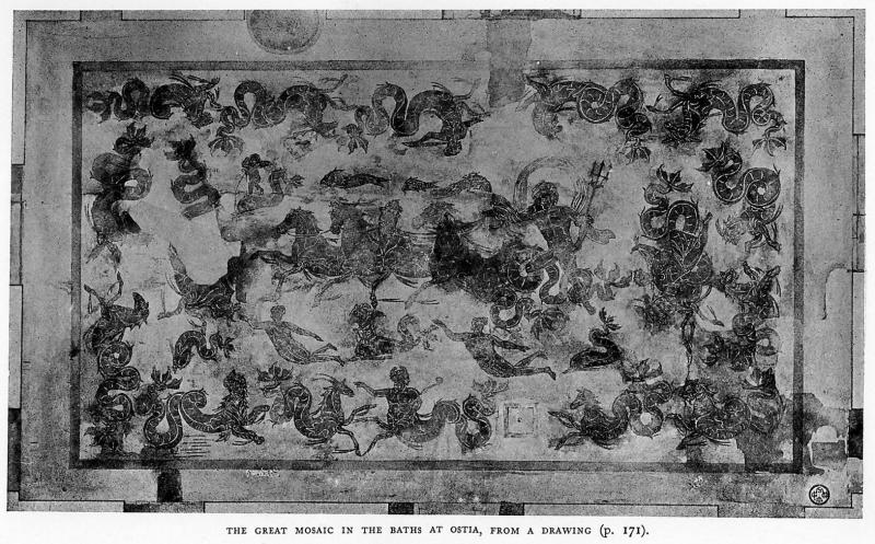
Plate X.
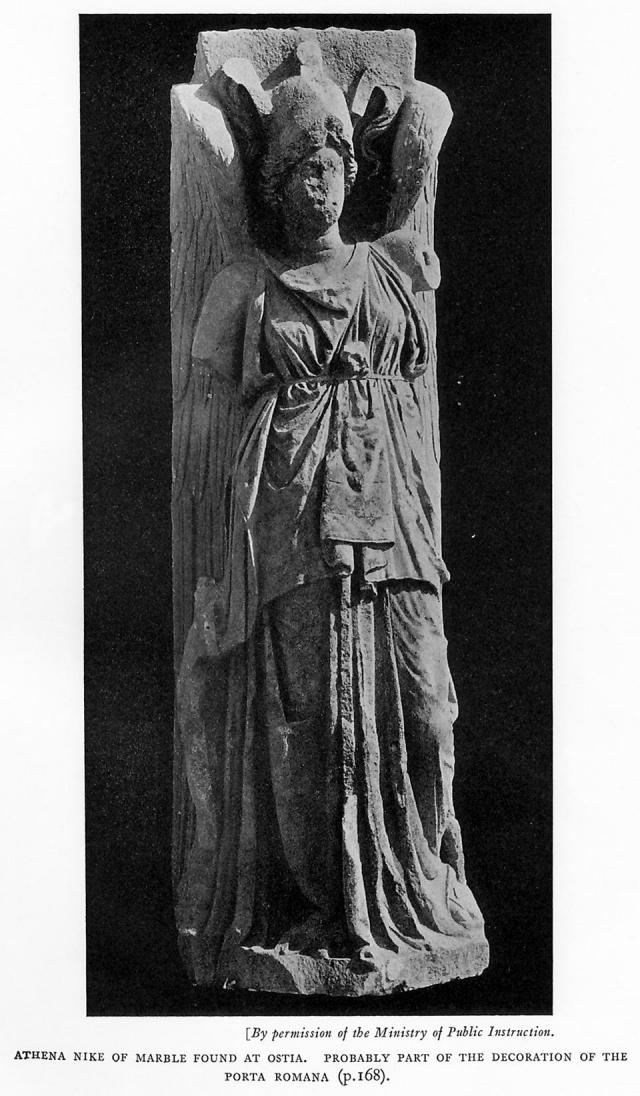
Plate XI.
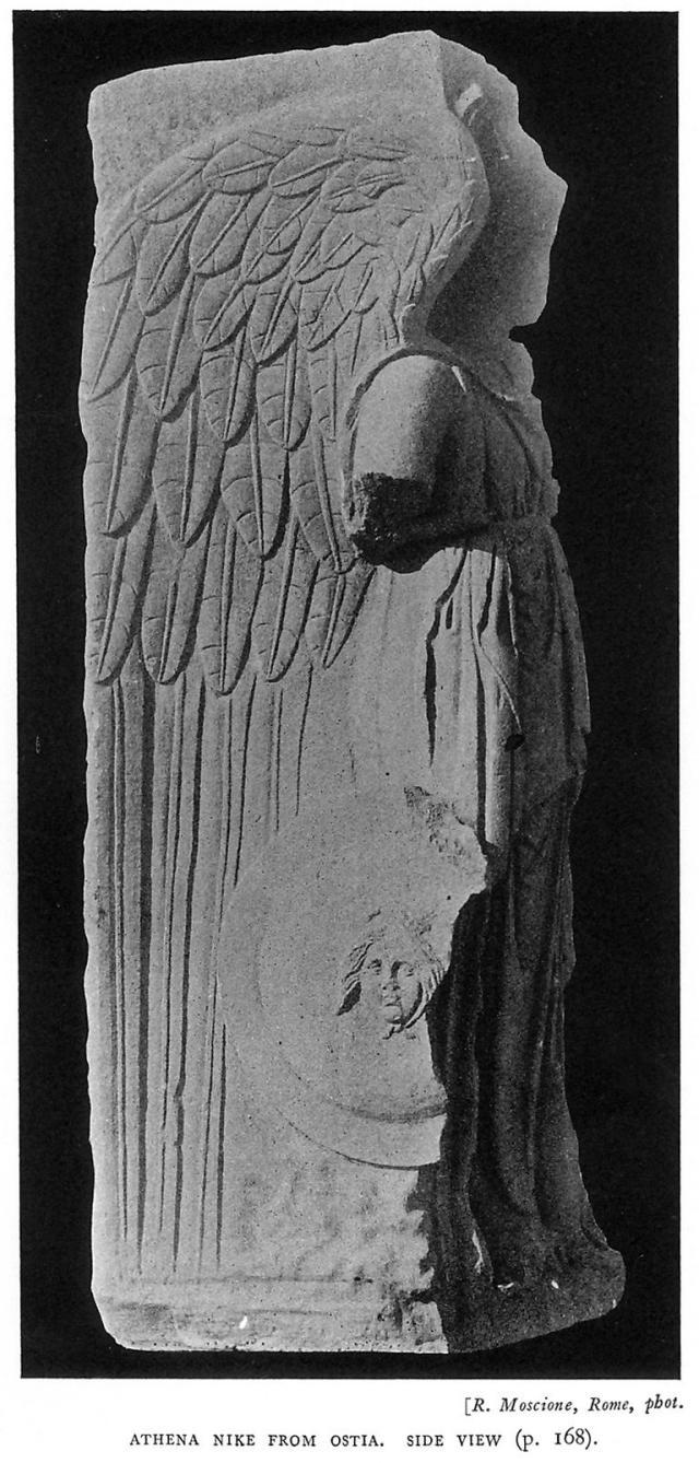
Plate XII.
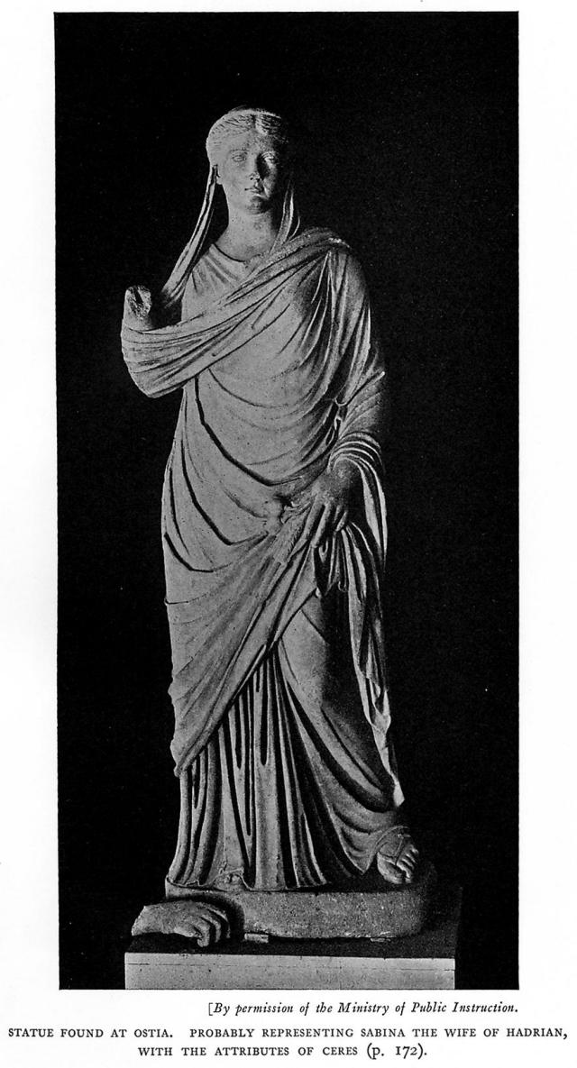
Plate XIII.
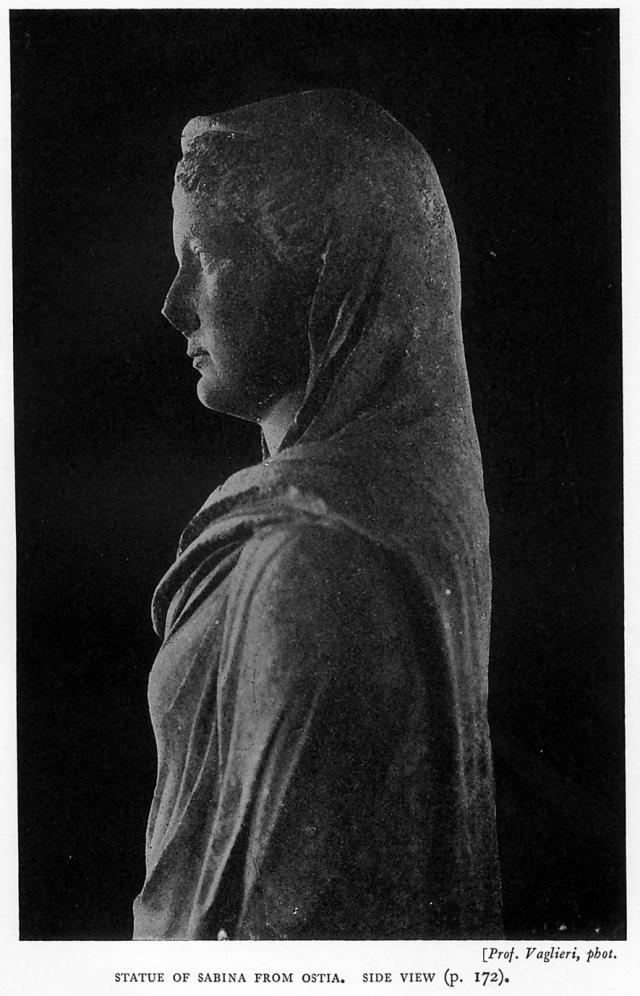
Plate XIV.