![]()
![]()
Isola Sacra - Central part - Land division
The geophysical research by the team of Simon Keay led to the discovery of land division on the central part of the Isola Sacra. Plots of land were separated by ditches used for drainage and wide enough for navigation by small boats. The plots were rectangular, and approximately 50 or 100 or 150 meters long. They may have been called strigae.
The division starts at c. 180 m. to the south of the Fossa Traiana. At the north end it is delimited by a west-east running road, leading to a bridge over the Portus to Ostia canal. The Via Flavia marks the western edge of the system. The canal seems to cut through the divisions, which should perhaps be dated to the late first century AD.
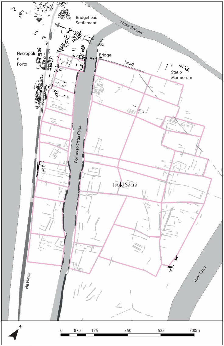
Map of the Isola Sacra with the layout of field-systems. Image: Keay 2020, fig. 6.4.
Two passages in the Liber Coloniarum, written in the fourth century AD, may be relevant:
| Ostiensis ager ab impp. Vespasiano, Traiano et Hadriano, in precisuris, in lacineis, et per strigas, colonis eorum est adsignatus, sed postea impp. Verus Antoninus et Commodus aliqua privatis concesserunt. | The Ostian territory was assigned by the Emperors Vespasian, Trajan, and Hadrian to their colonists, in parcels, in small pieces, and through furrows, but later the Emperors Verus Antoninus and Commodus donated some parts to private citizens. |
| Liber Coloniarum, 1, 236 (Rudorff, 1845). | |
| Nam pars agri quae circa Portum est Tiberis, in iugeribus adsignata adque oppidanis est tradita, et pro aestimio ubertatis professionem acceperunt. | Part of the land around Portus on the river Tiber was allocated in iugera [units of about 70 x 35 meters] and granted to townspeople, and they received a declaration according to the evaluation of its fertility. |
| Liber Coloniarum, 222, 11-13 (Rudorff, 1845). | |
![]()
![]()