![]()
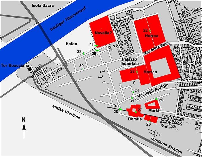
At the west end of region III the excavated area ends with the east part of a very large store building, between Via della Foce and Via degli Aurighi. Only the east wall and part of the south wall have been excavated: red opus latericium, characteristic for the Severan period, and partition walls of opus mixtum that may be older. The walls were reinforced by brick buttresses. The full extent of the building is known through geophysical research conducted by the German Archaeological Institute in Rome in 2000, under the direction of Michael Heinzelmann.
Top.
Detail of the characteristic red, Severan brickwork.
Photo: Jan Theo Bakker.
Right.
Plan of the excavated part of the horrea.
After SO I.Other buildings and structures that could be identified in the west part of region III are:
- Two small horrea to the west of Warehouse III,XVIII (plan nr. 23).
- Built in the second century AD.
- A market (nr. 25).
- The building has a trapezoidal plan (c. 40 x 60 metres). Shops surround a courtyard. The rooms were decorated with geometric black-and-white mosaics. Built in the early second century AD.
- A gate in the city wall, at the west end of the Cardo degli Aurighi (nr. 28).
- At this point the city wall was reinforced in the third century, perhaps during the reign of Aurelianus.
- A domus on top of the city wall (nr. 27).
- Built in the late first or early second century AD. A heated floor and marble decoration have been dated to the third century.
- Two small houses to the south of the city wall (nr. 26).
- Built in the second half of the first and in the second century AD. Later the two buildings were joined.
The west part of regions I and III with discoveries resulting from geophysical research.
Numbers indicate trenches. Plan: Michael Heinzelmann.
![]()