![]()
![]()
The aqueduct of Ostia was built during the early Empire, not later than the reign of Caligula (his name is found in stamps on lead water pipes). For the source of the aqueduct see the page about the Via Ostiensis, leading from Rome to Ostia.
The aqueduct reached Ostia 120 metres to the south of the Roman Gate. Here, to the east of the first century BC city wall, remains of the arches were found, and a hexagonal tower. The aqueduct arrived at a height of approximately 8 metres above sea-level. It will have taken at least 260 liters per second to the city, and perhaps as much as 400. A large reservoir with four compartments, covered by barrel vaults, was set against the inside of the city wall. The total length of the reservoir is 57 meters, the width 6 and the height 5. The water reached a height of approximately 2 meters, as can be deduced from the height of waterproof opus signinum. The reservoir could contain 720.000 - 785.000 liters. It was supported by 19 small rooms. The connection between the reservoir and the aqueduct has not been preserved.
In the reservoir Domitianic brick stamps were found, indicating that it was built in the late first century AD. According to Gemma Jansen it could not supply the entire city after the raising of the level of the city under Domitian and Hadrian: the level is too low to feed many reservoirs, and only one outgoing lead pipe was connected to it. She maintains that it was not the main distribution reservoir, the castellum aquae. The reservoir may have been filled with water to be used in times of shortage and to regulate the pressure. Perhaps the castellum was above the reservoir, or somewhere to the east of the city wall. A small basin on top of the city wall, at the point where the aqueduct arrived, might be related.
An inscription from 76-77 AD, found in the unexcavated south-east part of Ostia, near the city wall, mentions work on the aqueduct:
IMP(erator) CAESA[r Vesp]ASIANV[s Aug(ustus) pont(ifex) max(imus) tribibunic(ia) potestat(e)]
VIII IMP(erator) XVI[II p(ater) p(atriae) co(n)s(ul) VII design(atus)]
AQVAE DVCTVS IN COLONIA Os[t(iensi) (and then e.g. "specum novum sua impensa adiecit")]From the inscription has been deduced that during the reign of Vespasian the republican city wall became a branch of the aqueduct and supplied the south-west part of the city. The inscription may have been attached to a secondary city gate.
See the description of Nymphaeum III,VI,4 for a reconstruction drawing of the aqueduct on the city wall.
Cistern IV,VIII,2, near the Marine Gate, was also connected with the city wall. Here the gutter (specus) was at a height of c. 7.50 m.
A curious stretch of aqueduct can be see to the east of the Baths of the Forum. It may have been purely decorative, because it is higher (at least, as it was restored) than the maximum level of water pressure in Ostia.
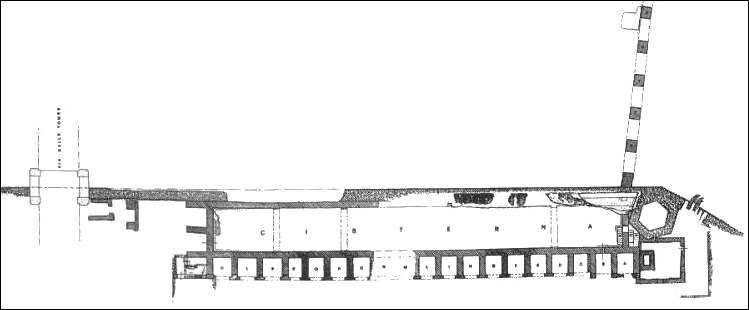
Plan of the aqueduct of Ostia reaching the city wall, and of the reservoirs. North is to the left.
From Scrinari - Ricciardi 1996, I, fig. 130.

Drawing of the remains of the aqueduct of Ostia and the reservoirs, seen from the north.
From Scrinari - Ricciardi 1996, I, fig. 131.
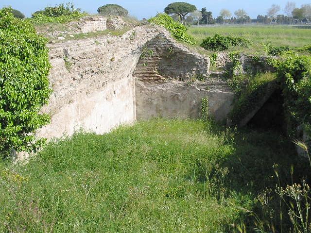
The south end of the reservoirs, seen from the north.
Photo: Jan Theo Bakker.
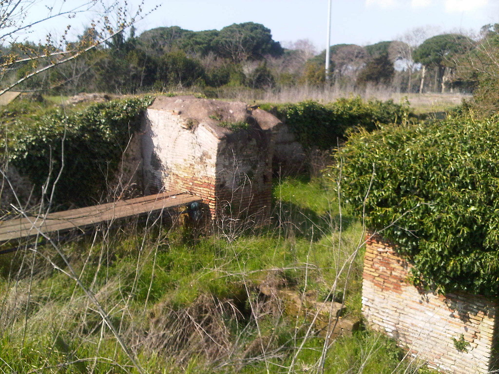
The arches of the aqueduct reaching the city wall, seen from the south-east.
Photo: Simon Bakker.
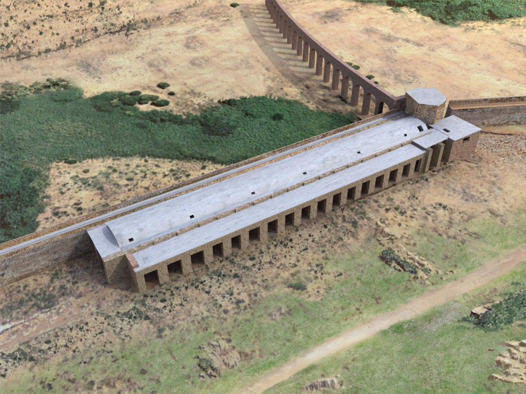
Reconstruction drawing of the aqueduct and the reservoirs, seen from the north-west.
From Bukowiecki - Dessales - Dubouloz 2008.
![]()
![]()